Chilón geodata
Chilón (Chiapas) is a seat of a second-order administrative division; located in Mexico in America/Mexico_City (GMT-6) time zone. With population of 7,368 people, there are 1259 cities with bigger population in this country. Compared to other cities in Mexico, 87.6% of cities are located further ↑North; 93.6% of cities are located further ←West and 61.9% of cities have higher elevation than Chilón. Note1


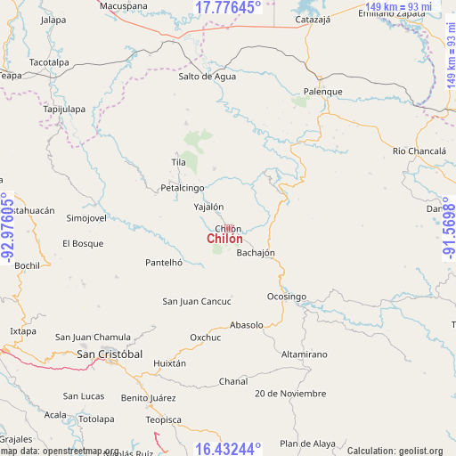
Chilón GPS coordinates[2]
17° 6' 20.376" North, 92° 16' 22.512" West
| Map corner | latitude | longitude |
|---|---|---|
| Upper-left | 17.77645°, | -92.97605° |
| Center: | 17.10566°, | -92.27292° |
| Lower-right: | 16.43244°, | -91.5698° |
| Map W x H: | 149.4×149.4 km | = 92.8×92.8mi |
| max Lat: | 32.7° ⇑87.6% North |
| Chilón: | 17.10566° |
| min Lat: | ⇓12.4% South 14.53588° |
| min Long | Chilón | max Long |
| -117.105° | -92.27292° | -86.73105° |
| W 93.6%⇐ | ⇒6.4% E |
Elevation
Elevation of Chilón is 883 m = 2897 ft, and this is 370.7 m = 1216 ft below average elevation for this country.
| Max E: |
3497 m = 11473 ft | 61.9% |
| Avg. | 1253.7 m = 4113 ft | |
| Chilón | 883 m = 2897 ft | |
Min E: |
-1 m = -3 ft | 38.1% |
See also: Mexico elevation on elevation.city.
Geographical zone
Chilón is located in North Torrid zone (between Equator and Tropic of Cancer). Distance of this Northern Tropic circle is 703.9 km =437.4 mi to North.| Distance of | km | miles | from Chilón |
|---|---|---|---|
| North Pole | 8105.1 | 5036.3 | to North |
| Arctic Circle | 5499.2 | 3417 | to North |
| Tropic Cancer | 703.9 | 437.4 | to North |
| Equator | 1902 | 1181.8 | to South |


Nearby cities:
15 places around Chilón: (largest is in red/bold)
• Aurora Grande
9.2 km =5.7 mi,  289°
289°
• Bachajón
11.5 km =7.1 mi,  129°
129°
• Corostic
12.3 km =7.6 mi,  79°
79°
• El Recreo
12.7 km =7.9 mi, 289°
• Insurgente Picoté
12.7 km =7.9 mi,  246°
246°
• Juan Sabines Verapaz
5.2 km =3.2 mi,  231°
231°
• San Antonio Bulujib
12.4 km =7.7 mi,  191°
191°
• Santa Cruz la Reforma
6.4 km =4 mi,  203°
203°
• Sitalá
9.8 km =6.1 mi, 201°
• Suluphuitz
12.3 km =7.6 mi,  30°
30°
• Tacuba Nueva
10.5 km =6.5 mi,  260°
260°
• Tzajalá
13.2 km =8.2 mi,  284°
284°
• Tzasibiltic
5 km =3.1 mi,  339°
339°
• Xaxajatic
13.3 km =8.3 mi,  68°
68°
• Yajalón
9.8 km =6.1 mi,  319°
319°
Sources, notices
• [Note1] Compared only with cities in Mexico existing in our database
• [Src1] Map data: © OpenStreetMap contributors (CC-BY-SA)
• [Src2] Other city data from geonames.org with taken over terms of usage.
• [Src3] Geographical zone / Annual Mean Temperature by Robert A. Rohde @ Wikipedia
