Escuchapa geodata
Escuchapa (Guerrero) is a populated place; located in Mexico in America/Mexico_City (GMT-6) time zone. With population of 609 people, there are 14153 cities with bigger population in this country. Compared to other cities in Mexico, 74.8% of cities are located further ↑North; 53.5% of cities are located further →East and 56.6% of cities have higher elevation than Escuchapa. Note1


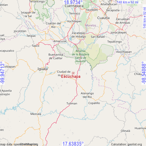
Escuchapa GPS coordinates[2]
18° 18' 25.776" North, 99° 14' 38.4" West
| Map corner | latitude | longitude |
|---|---|---|
| Upper-left | 18.9734°, | -99.94713° |
| Center: | 18.30716°, | -99.244° |
| Lower-right: | 17.63835°, | -98.54088° |
| Map W x H: | 148.4×148.4 km | = 92.2×92.2mi |
| max Lat: | 32.7° ⇑74.8% North |
| Escuchapa: | 18.30716° |
| min Lat: | ⇓25.2% South 14.53588° |
| min Long | Escuchapa | max Long |
| -117.105° | -99.244° | -86.73105° |
| W 46.5%⇐ | ⇒53.5% E |
Elevation
Elevation of Escuchapa is 1136 m = 3727 ft, and this is 117.7 m = 386 ft below average elevation for this country.
| Max E: |
3497 m = 11473 ft | 56.6% |
| Avg. | 1253.7 m = 4113 ft | |
| Escuchapa | 1136 m = 3727 ft | |
Min E: |
-1 m = -3 ft | 43.4% |
See also: Mexico elevation on elevation.city.
Geographical zone
Escuchapa is located in North Torrid zone (between Equator and Tropic of Cancer). Distance of this Northern Tropic circle is 570.4 km =354.4 mi to North.| Distance of | km | miles | from Escuchapa |
|---|---|---|---|
| North Pole | 7971.5 | 4953.3 | to North |
| Arctic Circle | 5365.6 | 3334 | to North |
| Tropic Cancer | 570.4 | 354.4 | to North |
| Equator | 2035.6 | 1264.9 | to South |


Nearby cities:
15 places around Escuchapa: (largest is in red/bold)
• Apanguito
19.7 km =12.2 mi,  147°
147°
• Atetetla
13.8 km =8.6 mi,  279°
279°
• Cacahuananche
17.6 km =10.9 mi,  222°
222°
• Chaucingo
13.6 km =8.5 mi,  93°
93°
• Ciudad de Huitzuco
9.5 km =5.9 mi,  267°
267°
• Cuexcontlán
19.5 km =12.1 mi, 269°
• Lagunillas
11.5 km =7.1 mi,  209°
209°
• Paso Morelos
10.2 km =6.3 mi,  159°
159°
• Pololcingo
15.9 km =9.9 mi,  259°
259°
• Quetzalapa
6.7 km =4.2 mi,  62°
62°
• San Juan Teocalcingo
15.5 km =9.6 mi,  54°
54°
• San Miguel de las Palmas
7.6 km =4.7 mi,  143°
143°
• San Vicente Palapa
17.7 km =11 mi, 276°
• Tlapala
13.5 km =8.4 mi,  233°
233°
• Tlaxmalac
18.8 km =11.7 mi,  288°
288°
Sources, notices
• [Note1] Compared only with cities in Mexico existing in our database
• [Src1] Map data: © OpenStreetMap contributors (CC-BY-SA)
• [Src2] Other city data from geonames.org with taken over terms of usage.
• [Src3] Geographical zone / Annual Mean Temperature by Robert A. Rohde @ Wikipedia
