Lagunillas geodata
Lagunillas (Guerrero) is a populated place; located in Mexico in America/Mexico_City (GMT-6) time zone. With population of 606 people, there are 14202 cities with bigger population in this country. Compared to other cities in Mexico, 76% of cities are located further ↑North; 54.2% of cities are located further →East and 55.2% of cities have higher elevation than Lagunillas. Note1


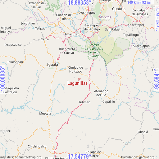
Lagunillas GPS coordinates[2]
18° 13' 0.984" North, 99° 17' 49.992" West
| Map corner | latitude | longitude |
|---|---|---|
| Upper-left | 18.88353°, | -100.00035° |
| Center: | 18.21694°, | -99.29722° |
| Lower-right: | 17.54779°, | -98.5941° |
| Map W x H: | 148.5×148.5 km | = 92.3×92.3mi |
| max Lat: | 32.7° ⇑76% North |
| Lagunillas: | 18.21694° |
| min Lat: | ⇓24% South 14.53588° |
| min Long | Lagunillas | max Long |
| -117.105° | -99.29722° | -86.73105° |
| W 45.8%⇐ | ⇒54.2% E |
Elevation
Elevation of Lagunillas is 1190 m = 3904 ft, and this is 63.7 m = 209 ft below average elevation for this country.
| Max E: |
3497 m = 11473 ft | 55.2% |
| Avg. | 1253.7 m = 4113 ft | |
| Lagunillas | 1190 m = 3904 ft | |
Min E: |
-1 m = -3 ft | 44.8% |
See also: Mexico elevation on elevation.city.
Geographical zone
Lagunillas is located in North Torrid zone (between Equator and Tropic of Cancer). Distance of this Northern Tropic circle is 580.4 km =360.6 mi to North.| Distance of | km | miles | from Lagunillas |
|---|---|---|---|
| North Pole | 7981.5 | 4959.5 | to North |
| Arctic Circle | 5375.6 | 3340.2 | to North |
| Tropic Cancer | 580.4 | 360.6 | to North |
| Equator | 2025.5 | 1258.6 | to South |


Nearby cities:
15 places around Lagunillas: (largest is in red/bold)
• Atetetla
14.7 km =9.1 mi,  327°
327°
• Cacahuananche
7 km =4.3 mi,  245°
245°
• Ciudad de Huitzuco
10.4 km =6.5 mi,  338°
338°
• Cuexcontlán
17 km =10.6 mi,  305°
305°
• Escuchapa
11.5 km =7.1 mi,  29°
29°
• Mayanalán
15.1 km =9.4 mi, 251°
• Paso Morelos
9.2 km =5.7 mi,  87°
87°
• Pololcingo
12.3 km =7.6 mi, 305°
• Quetzalapa
17.5 km =10.9 mi,  41°
41°
• San Miguel de las Palmas
10.9 km =6.8 mi,  69°
69°
• San Vicente Palapa
16.9 km =10.5 mi, 314°
• Santa Cruz
11.5 km =7.1 mi,  264°
264°
• Tequicuilco
16.4 km =10.2 mi,  140°
140°
• Tlapala
5.6 km =3.5 mi,  290°
290°
• Xilocintla
10.5 km =6.5 mi,  239°
239°
Sources, notices
• [Note1] Compared only with cities in Mexico existing in our database
• [Src1] Map data: © OpenStreetMap contributors (CC-BY-SA)
• [Src2] Other city data from geonames.org with taken over terms of usage.
• [Src3] Geographical zone / Annual Mean Temperature by Robert A. Rohde @ Wikipedia
