Apatzingán geodata
Apatzingán (Tabasco) is a populated place; located in Mexico in America/Mexico_City (GMT-6) time zone. With population of 1,096 people, there are 7931 cities with bigger population in this country. Compared to other cities in Mexico, 82.1% of cities are located further ↑North; 96.7% of cities are located further ←West and 84.5% of cities have higher elevation than Apatzingán. Note1


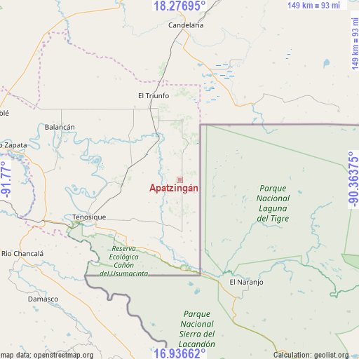
Apatzingán GPS coordinates[2]
17° 36' 28.908" North, 91° 4' 0.732" West
| Map corner | latitude | longitude |
|---|---|---|
| Upper-left | 18.27695°, | -91.77° |
| Center: | 17.60803°, | -91.06687° |
| Lower-right: | 16.93662°, | -90.36375° |
| Map W x H: | 149×149 km | = 92.6×92.6mi |
| max Lat: | 32.7° ⇑82.1% North |
| Apatzingán: | 17.60803° |
| min Lat: | ⇓17.9% South 14.53588° |
| min Long | Apatzingán | max Long |
| -117.105° | -91.06687° | -86.73105° |
| W 96.7%⇐ | ⇒3.3% E |
Elevation
Elevation of Apatzingán is 48 m = 157 ft, and this is 1205.7 m = 3956 ft below average elevation for this country.
| Max E: |
3497 m = 11473 ft | 84.5% |
| Avg. | 1253.7 m = 4113 ft | |
| Apatzingán | 48 m = 157 ft | |
Min E: |
-1 m = -3 ft | 15.5% |
See also: Mexico elevation on elevation.city.
Geographical zone
Apatzingán is located in North Torrid zone (between Equator and Tropic of Cancer). Distance of this Northern Tropic circle is 648.1 km =402.7 mi to North.| Distance of | km | miles | from Apatzingán |
|---|---|---|---|
| North Pole | 8049.2 | 5001.5 | to North |
| Arctic Circle | 5443.3 | 3382.3 | to North |
| Tropic Cancer | 648.1 | 402.7 | to North |
| Equator | 1957.8 | 1216.5 | to South |


Nearby cities:
15 places around Apatzingán: (largest is in red/bold)
• Capitán Felipe Castellanos Díaz (San Pedro)
20.2 km =12.6 mi,  335°
335°
• Cuauhtémoc
25 km =15.5 mi,  2°
2°
• El Capulín
11.2 km =7 mi,  348°
348°
• El Chamizal
12.4 km =7.7 mi,  174°
174°
• El Mical
24.9 km =15.5 mi, 1°
• El Palmar
18 km =11.2 mi, 170°
• El Águila
21.6 km =13.4 mi,  283°
283°
• Ingeniero Emilio López Zamora
24.5 km =15.2 mi, 1°
• Jolochero
9.3 km =5.8 mi,  186°
186°
• Los Cenotes
4.3 km =2.7 mi,  46°
46°
• Mactún
24 km =14.9 mi,  265°
265°
• Paraíso (El Tinto)
8.4 km =5.2 mi,  253°
253°
• Quetzalcóatl (Cuatro Poblados)
24.6 km =15.3 mi, 2°
• San Carlos
11.1 km =6.9 mi,  236°
236°
• Santa Cruz
21.6 km =13.4 mi, 168°
Sources, notices
• [Note1] Compared only with cities in Mexico existing in our database
• [Src1] Map data: © OpenStreetMap contributors (CC-BY-SA)
• [Src2] Other city data from geonames.org with taken over terms of usage.
• [Src3] Geographical zone / Annual Mean Temperature by Robert A. Rohde @ Wikipedia
