Aljojuca geodata
Aljojuca (Puebla) is a populated place; located in Mexico in America/Mexico_City (GMT-6) time zone. With population of 3,821 people, there are 2392 cities with bigger population in this country. Compared to other cities in Mexico, 63.1% of cities are located further ↑North; 69.2% of cities are located further ←West and 92% of cities have lower elevation than Aljojuca. Note1


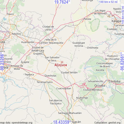
Aljojuca GPS coordinates[2]
19° 5' 57.588" North, 97° 31' 47.028" West
| Map corner | latitude | longitude |
|---|---|---|
| Upper-left | 19.7624°, | -98.23286° |
| Center: | 19.09933°, | -97.52973° |
| Lower-right: | 18.43359°, | -96.82661° |
| Map W x H: | 147.7×147.8 km | = 91.8×91.8mi |
| max Lat: | 32.7° ⇑63.1% North |
| Aljojuca: | 19.09933° |
| min Lat: | ⇓36.9% South 14.53588° |
| min Long | Aljojuca | max Long |
| -117.105° | -97.52973° | -86.73105° |
| W 69.2%⇐ | ⇒30.8% E |
Elevation
Elevation of Aljojuca is 2485 m = 8153 ft, and this is 1231.3 m = 4040 ft above average elevation for this country.
| Max E: |
3497 m = 11473 ft | 8% |
| Aljojuca | 2485 m 8153 ft | |
| Avg. | 1253.7 m = 4113 ft | |
Min E: |
-1 m = -3 ft | 92% |
See also: Mexico elevation on elevation.city.
Geographical zone
Aljojuca is located in North Torrid zone (between Equator and Tropic of Cancer). Distance of this Northern Tropic circle is 482.3 km =299.7 mi to North.| Distance of | km | miles | from Aljojuca |
|---|---|---|---|
| North Pole | 7883.4 | 4898.5 | to North |
| Arctic Circle | 5277.5 | 3279.3 | to North |
| Tropic Cancer | 482.3 | 299.7 | to North |
| Equator | 2123.6 | 1319.5 | to South |


Nearby cities:
15 places around Aljojuca: (largest is in red/bold)
• Ahuatepec de Camino
11.9 km =7.4 mi,  123°
123°
• Guadalupe Victoria
8 km =5 mi,  274°
274°
• José María Morelos
8 km =5 mi,  54°
54°
• Miguel Hidalgo
11.9 km =7.4 mi,  5°
5°
• San Diego Texmelucan
11.9 km =7.4 mi,  137°
137°
• San Francisco Independencia (Santa María Aserradero)
11 km =6.8 mi,  107°
107°
• San José Guerrero
11.7 km =7.3 mi,  184°
184°
• San Juan Atenco
1.8 km =1.1 mi,  219°
219°
• San Miguel Ocotenco
8.9 km =5.5 mi, 114°
• San Miguel Tecuitlapa
3 km =1.9 mi,  323°
323°
• San Nicolas Buenos Aires
7.6 km =4.7 mi,  342°
342°
• San Salvador El Seco
12.4 km =7.7 mi,  287°
287°
• Santa Cruz Coyotepec
9.2 km =5.7 mi,  200°
200°
• Santa Maria Coatepec
6.7 km =4.2 mi,  279°
279°
• Tlachichuca
11.7 km =7.3 mi,  81°
81°
Sources, notices
• [Note1] Compared only with cities in Mexico existing in our database
• [Src1] Map data: © OpenStreetMap contributors (CC-BY-SA)
• [Src2] Other city data from geonames.org with taken over terms of usage.
• [Src3] Geographical zone / Annual Mean Temperature by Robert A. Rohde @ Wikipedia
