Guadalupe Victoria geodata
Guadalupe Victoria (Puebla) is a populated place; located in Mexico in America/Mexico_City (GMT-6) time zone. With population of 1,082 people, there are 8049 cities with bigger population in this country. Compared to other cities in Mexico, 63% of cities are located further ↑North; 68.4% of cities are located further ←West and 91.1% of cities have lower elevation than Guadalupe Victoria. Note1


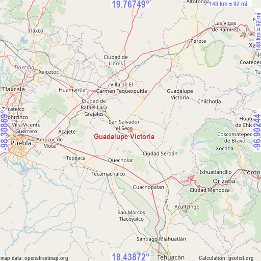
Guadalupe Victoria GPS coordinates[2]
19° 6' 15.984" North, 97° 36' 20.016" West
| Map corner | latitude | longitude |
|---|---|---|
| Upper-left | 19.76749°, | -98.30869° |
| Center: | 19.10444°, | -97.60556° |
| Lower-right: | 18.43872°, | -96.90244° |
| Map W x H: | 147.7×147.7 km | = 91.8×91.8mi |
| max Lat: | 32.7° ⇑63% North |
| Guadalupe Victoria: | 19.10444° |
| min Lat: | ⇓37% South 14.53588° |
| min Long | Guadalupe Victo | max Long |
| -117.105° | -97.60556° | -86.73105° |
| W 68.4%⇐ | ⇒31.6% E |
Elevation
Elevation of Guadalupe Victoria is 2443 m = 8015 ft, and this is 1189.3 m = 3902 ft above average elevation for this country.
| Max E: |
3497 m = 11473 ft | 8.9% |
| Guadalupe Victoria | 2443 m 8015 ft | |
| Avg. | 1253.7 m = 4113 ft | |
Min E: |
-1 m = -3 ft | 91.1% |
See also: Mexico elevation on elevation.city.
Geographical zone
Guadalupe Victoria is located in North Torrid zone (between Equator and Tropic of Cancer). Distance of this Northern Tropic circle is 481.7 km =299.3 mi to North.| Distance of | km | miles | from Guadalupe Victoria |
|---|---|---|---|
| North Pole | 7882.8 | 4898.1 | to North |
| Arctic Circle | 5277 | 3279 | to North |
| Tropic Cancer | 481.7 | 299.3 | to North |
| Equator | 2124.2 | 1319.9 | to South |


Nearby cities:
15 places around Guadalupe Victoria: (largest is in red/bold)
• Aljojuca
8 km =5 mi,  94°
94°
• Candelaria Portezuelo
12.2 km =7.6 mi,  235°
235°
• Mazapiltepec
10.3 km =6.4 mi,  279°
279°
• San José Barroso
9.6 km =6 mi,  349°
349°
• San Juan Atenco
7.1 km =4.4 mi,  106°
106°
• San Martín Rinconada
6.7 km =4.2 mi,  286°
286°
• San Miguel Tecuitlapa
6.4 km =4 mi,  73°
73°
• San Nicolas Buenos Aires
8.8 km =5.5 mi,  40°
40°
• San Salvador El Seco
5 km =3.1 mi,  310°
310°
• San Sebastián Villanueva
12.9 km =8 mi,  247°
247°
• Santa Catarina Villanueva
11.7 km =7.3 mi,  184°
184°
• Santa Cruz Coyotepec
10.3 km =6.4 mi,  152°
152°
• Santa Maria Coatepec
1.5 km =0.9 mi, 68°
• Santiago Tenango
12 km =7.5 mi,  199°
199°
• Soltepec
11 km =6.8 mi, 279°
Sources, notices
• [Note1] Compared only with cities in Mexico existing in our database
• [Src1] Map data: © OpenStreetMap contributors (CC-BY-SA)
• [Src2] Other city data from geonames.org with taken over terms of usage.
• [Src3] Geographical zone / Annual Mean Temperature by Robert A. Rohde @ Wikipedia
