Alcozauca de Guerrero geodata
Alcozauca de Guerrero (Guerrero) is a seat of a second-order administrative division; located in Mexico in America/Mexico_City (GMT-6) time zone. With population of 2,545 people, there are 3482 cities with bigger population in this country. Compared to other cities in Mexico, 83.5% of cities are located further ↑North; 58.8% of cities are located further ←West and 52.1% of cities have higher elevation than Alcozauca de Guerrero. Note1


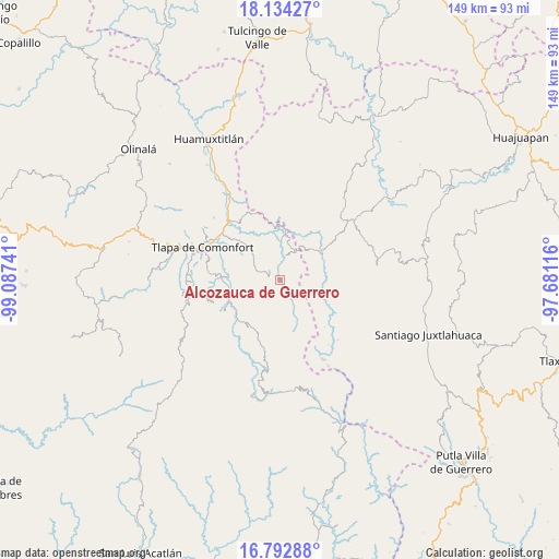
Alcozauca de Guerrero GPS coordinates[2]
17° 27' 53.316" North, 98° 23' 3.408" West
| Map corner | latitude | longitude |
|---|---|---|
| Upper-left | 18.13427°, | -99.08741° |
| Center: | 17.46481°, | -98.38428° |
| Lower-right: | 16.79288°, | -97.68116° |
| Map W x H: | 149.1×149.2 km | = 92.6×92.7mi |
| max Lat: | 32.7° ⇑83.5% North |
| Alcozauca de Guerrero: | 17.46481° |
| min Lat: | ⇓16.5% South 14.53588° |
| min Long | Alcozauca de Gu | max Long |
| -117.105° | -98.38428° | -86.73105° |
| W 58.8%⇐ | ⇒41.2% E |
Elevation
Elevation of Alcozauca de Guerrero is 1333 m = 4373 ft, and this is 79.3 m = 260 ft above average elevation for this country.
| Max E: |
3497 m = 11473 ft | 52.1% |
| Alcozauca de Guerrero | 1333 m 4373 ft | |
| Avg. | 1253.7 m = 4113 ft | |
Min E: |
-1 m = -3 ft | 47.9% |
See also: Mexico elevation on elevation.city.
Geographical zone
Alcozauca de Guerrero is located in North Torrid zone (between Equator and Tropic of Cancer). Distance of this Northern Tropic circle is 664 km =412.6 mi to North.| Distance of | km | miles | from Alcozauca de Guerrero |
|---|---|---|---|
| North Pole | 8065.2 | 5011.5 | to North |
| Arctic Circle | 5459.3 | 3392.3 | to North |
| Tropic Cancer | 664 | 412.6 | to North |
| Equator | 1941.9 | 1206.6 | to South |


Nearby cities:
15 places around Alcozauca de Guerrero: (largest is in red/bold)
• Ahuajutla
10.7 km =6.6 mi,  110°
110°
• Almolonga de Ocampo (Almolonga)
5.9 km =3.7 mi,  147°
147°
• Calihualá
13.5 km =8.4 mi,  56°
56°
• Cuba Libre
12.2 km =7.6 mi,  277°
277°
• Cuyuxtlahuaca
4.6 km =2.9 mi,  65°
65°
• El Platanar (Santa María Guadalupe el Platanar)
13.2 km =8.2 mi, 281°
• Guadalupe Nogales
8.2 km =5.1 mi,  78°
78°
• La Luz de Juárez
8.7 km =5.4 mi,  26°
26°
• Melchor Ocampo
13.5 km =8.4 mi,  209°
209°
• San Francisco Tlapancingo
12.5 km =7.8 mi, 80°
• Santa Cruz
7.8 km =4.8 mi,  345°
345°
• Tlahuapa
11.2 km =7 mi, 153°
• Tlalixtaquilla
12.6 km =7.8 mi,  8°
8°
• Xochapa
11.4 km =7.1 mi,  218°
218°
• Xonacatlán
5.1 km =3.2 mi,  324°
324°
Sources, notices
• [Note1] Compared only with cities in Mexico existing in our database
• [Src1] Map data: © OpenStreetMap contributors (CC-BY-SA)
• [Src2] Other city data from geonames.org with taken over terms of usage.
• [Src3] Geographical zone / Annual Mean Temperature by Robert A. Rohde @ Wikipedia
