Xochapa geodata
Xochapa (Guerrero) is a populated place; located in Mexico in America/Mexico_City (GMT-6) time zone. With population of 1,565 people, there are 5519 cities with bigger population in this country. Compared to other cities in Mexico, 84.4% of cities are located further ↑North; 57.9% of cities are located further ←West and 50.2% of cities have lower elevation than Xochapa. Note1


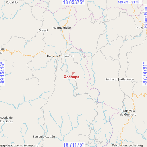
Xochapa GPS coordinates[2]
17° 23' 2.328" North, 98° 27' 3.708" West
| Map corner | latitude | longitude |
|---|---|---|
| Upper-left | 18.05375°, | -99.15416° |
| Center: | 17.38398°, | -98.45103° |
| Lower-right: | 16.71175°, | -97.74791° |
| Map W x H: | 149.2×149.2 km | = 92.7×92.7mi |
| max Lat: | 32.7° ⇑84.4% North |
| Xochapa: | 17.38398° |
| min Lat: | ⇓15.6% South 14.53588° |
| min Long | Xochapa | max Long |
| -117.105° | -98.45103° | -86.73105° |
| W 57.9%⇐ | ⇒42.1% E |
Elevation
Elevation of Xochapa is 1440 m = 4724 ft, and this is 186.3 m = 611 ft above average elevation for this country.
| Max E: |
3497 m = 11473 ft | 49.8% |
| Xochapa | 1440 m 4724 ft | |
| Avg. | 1253.7 m = 4113 ft | |
Min E: |
-1 m = -3 ft | 50.2% |
See also: Mexico elevation on elevation.city.
Geographical zone
Xochapa is located in North Torrid zone (between Equator and Tropic of Cancer). Distance of this Northern Tropic circle is 673 km =418.2 mi to North.| Distance of | km | miles | from Xochapa |
|---|---|---|---|
| North Pole | 8074.1 | 5017 | to North |
| Arctic Circle | 5468.3 | 3397.8 | to North |
| Tropic Cancer | 673 | 418.2 | to North |
| Equator | 1932.9 | 1201 | to South |


Nearby cities:
15 places around Xochapa: (largest is in red/bold)
• Alcozauca de Guerrero
11.4 km =7.1 mi,  38°
38°
• Almolonga de Ocampo (Almolonga)
11 km =6.8 mi,  68°
68°
• Cahuatache
9.3 km =5.8 mi,  292°
292°
• Cocuilotlazala
9.6 km =6 mi,  164°
164°
• Cuba Libre
11.8 km =7.3 mi,  335°
335°
• Francisco I. Madero
10.6 km =6.6 mi,  215°
215°
• Igualita
11 km =6.8 mi,  320°
320°
• Juanacatlán
9 km =5.6 mi,  225°
225°
• Lomazóyatl (Lomazoya)
3.5 km =2.2 mi,  196°
196°
• Melchor Ocampo
2.8 km =1.7 mi,  172°
172°
• San Vicente Zoyatlán
11.5 km =7.1 mi,  126°
126°
• Santa Cruz
11.8 km =7.3 mi, 231°
• Santa María Tonaya
7.2 km =4.5 mi,  256°
256°
• Tlahuapa
12.1 km =7.5 mi,  94°
94°
• Xilotepec (Jilotepec Chiquito)
11 km =6.8 mi,  282°
282°
Sources, notices
• [Note1] Compared only with cities in Mexico existing in our database
• [Src1] Map data: © OpenStreetMap contributors (CC-BY-SA)
• [Src2] Other city data from geonames.org with taken over terms of usage.
• [Src3] Geographical zone / Annual Mean Temperature by Robert A. Rohde @ Wikipedia
