Xonacatlán geodata
Xonacatlán (Guerrero) is a populated place; located in Mexico in America/Mexico_City (GMT-6) time zone. With population of 740 people, there are 11812 cities with bigger population in this country. Compared to other cities in Mexico, 83.1% of cities are located further ↑North; 58.5% of cities are located further ←West and 58.3% of cities have lower elevation than Xonacatlán. Note1


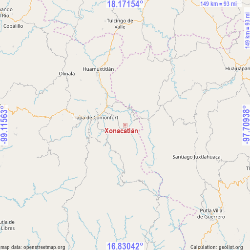
Xonacatlán GPS coordinates[2]
17° 30' 7.992" North, 98° 24' 45" West
| Map corner | latitude | longitude |
|---|---|---|
| Upper-left | 18.17154°, | -99.11563° |
| Center: | 17.50222°, | -98.4125° |
| Lower-right: | 16.83042°, | -97.70938° |
| Map W x H: | 149.1×149.1 km | = 92.6×92.6mi |
| max Lat: | 32.7° ⇑83.1% North |
| Xonacatlán: | 17.50222° |
| min Lat: | ⇓16.9% South 14.53588° |
| min Long | Xonacatlán | max Long |
| -117.105° | -98.4125° | -86.73105° |
| W 58.5%⇐ | ⇒41.5% E |
Elevation
Elevation of Xonacatlán is 1695 m = 5561 ft, and this is 441.3 m = 1448 ft above average elevation for this country.
| Max E: |
3497 m = 11473 ft | 41.7% |
| Xonacatlán | 1695 m 5561 ft | |
| Avg. | 1253.7 m = 4113 ft | |
Min E: |
-1 m = -3 ft | 58.3% |
See also: Mexico elevation on elevation.city.
Geographical zone
Xonacatlán is located in North Torrid zone (between Equator and Tropic of Cancer). Distance of this Northern Tropic circle is 659.9 km =410 mi to North.| Distance of | km | miles | from Xonacatlán |
|---|---|---|---|
| North Pole | 8061 | 5008.9 | to North |
| Arctic Circle | 5455.1 | 3389.6 | to North |
| Tropic Cancer | 659.9 | 410 | to North |
| Equator | 1946.1 | 1209.3 | to South |


Nearby cities:
15 places around Xonacatlán: (largest is in red/bold)
• Ahuajutla
15.2 km =9.4 mi,  121°
121°
• Alcozauca de Guerrero
5.1 km =3.2 mi,  144°
144°
• Almolonga de Ocampo (Almolonga)
11 km =6.8 mi,  146°
146°
• Calihualá
14.6 km =9.1 mi,  77°
77°
• Cuba Libre
9.4 km =5.8 mi,  254°
254°
• Cuyuxtlahuaca
7.5 km =4.7 mi,  107°
107°
• El Platanar (Santa María Guadalupe el Platanar)
10.1 km =6.3 mi,  260°
260°
• Guadalupe Nogales
11.3 km =7 mi,  102°
102°
• Igualita
12 km =7.5 mi, 247°
• La Luz de Juárez
7.7 km =4.8 mi,  61°
61°
• Santa Cruz
3.6 km =2.2 mi,  16°
16°
• Tecoyame de Guadalupe
14.2 km =8.8 mi,  342°
342°
• Tlachichilco
15.2 km =9.4 mi,  28°
28°
• Tlalixtaquilla
9.6 km =6 mi, 30°
• Xochapa
13.8 km =8.6 mi,  197°
197°
Sources, notices
• [Note1] Compared only with cities in Mexico existing in our database
• [Src1] Map data: © OpenStreetMap contributors (CC-BY-SA)
• [Src2] Other city data from geonames.org with taken over terms of usage.
• [Src3] Geographical zone / Annual Mean Temperature by Robert A. Rohde @ Wikipedia
