Cuyuxtlahuaca geodata
Cuyuxtlahuaca (Guerrero) is a populated place; located in Mexico in America/Mexico_City (GMT-6) time zone. With population of 1,480 people, there are 5826 cities with bigger population in this country. Compared to other cities in Mexico, 83.3% of cities are located further ↑North; 59.3% of cities are located further ←West and 58.2% of cities have lower elevation than Cuyuxtlahuaca. Note1


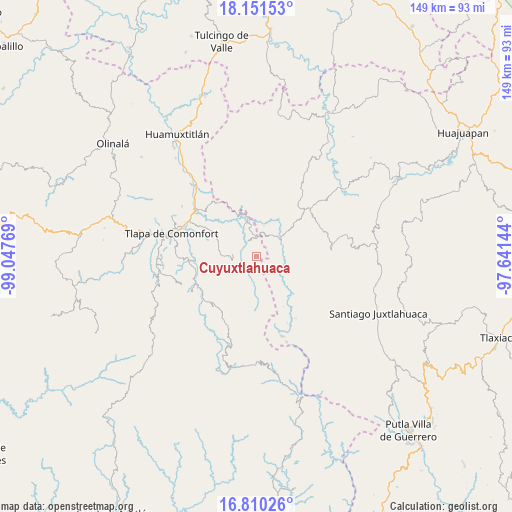
Cuyuxtlahuaca GPS coordinates[2]
17° 28' 55.668" North, 98° 20' 40.416" West
| Map corner | latitude | longitude |
|---|---|---|
| Upper-left | 18.15153°, | -99.04769° |
| Center: | 17.48213°, | -98.34456° |
| Lower-right: | 16.81026°, | -97.64144° |
| Map W x H: | 149.1×149.1 km | = 92.6×92.6mi |
| max Lat: | 32.7° ⇑83.3% North |
| Cuyuxtlahuaca: | 17.48213° |
| min Lat: | ⇓16.7% South 14.53588° |
| min Long | Cuyuxtlahuaca | max Long |
| -117.105° | -98.34456° | -86.73105° |
| W 59.3%⇐ | ⇒40.7% E |
Elevation
Elevation of Cuyuxtlahuaca is 1694 m = 5558 ft, and this is 440.3 m = 1445 ft above average elevation for this country.
| Max E: |
3497 m = 11473 ft | 41.8% |
| Cuyuxtlahuaca | 1694 m 5558 ft | |
| Avg. | 1253.7 m = 4113 ft | |
Min E: |
-1 m = -3 ft | 58.2% |
See also: Mexico elevation on elevation.city.
Geographical zone
Cuyuxtlahuaca is located in North Torrid zone (between Equator and Tropic of Cancer). Distance of this Northern Tropic circle is 662.1 km =411.4 mi to North.| Distance of | km | miles | from Cuyuxtlahuaca |
|---|---|---|---|
| North Pole | 8063.2 | 5010.2 | to North |
| Arctic Circle | 5457.3 | 3391 | to North |
| Tropic Cancer | 662.1 | 411.4 | to North |
| Equator | 1943.8 | 1207.8 | to South |


Nearby cities:
15 places around Cuyuxtlahuaca: (largest is in red/bold)
• Ahuajutla
8.1 km =5 mi,  134°
134°
• Alcozauca de Guerrero
4.6 km =2.9 mi,  245°
245°
• Almolonga de Ocampo (Almolonga)
7 km =4.3 mi,  188°
188°
• Calihualá
8.9 km =5.5 mi,  52°
52°
• Cuba Libre
16.3 km =10.1 mi,  269°
269°
• Guadalupe Nogales
3.9 km =2.4 mi,  94°
94°
• La Luz de Juárez
5.9 km =3.7 mi,  356°
356°
• San Francisco Tlapancingo
8.1 km =5 mi, 89°
• Santa Cruz
8.4 km =5.2 mi,  312°
312°
• Santa Cruz de Bravo
16.9 km =10.5 mi, 49°
• Tlachichilco
15.6 km =9.7 mi,  0°
0°
• Tlahuapa
11.9 km =7.4 mi,  176°
176°
• Tlalixtaquilla
10.8 km =6.7 mi,  347°
347°
• Xochapa
15.7 km =9.8 mi,  225°
225°
• Xonacatlán
7.5 km =4.7 mi,  287°
287°
Sources, notices
• [Note1] Compared only with cities in Mexico existing in our database
• [Src1] Map data: © OpenStreetMap contributors (CC-BY-SA)
• [Src2] Other city data from geonames.org with taken over terms of usage.
• [Src3] Geographical zone / Annual Mean Temperature by Robert A. Rohde @ Wikipedia
