Santa Cruz geodata
Santa Cruz (Guerrero) is a populated place; located in Mexico in America/Mexico_City (GMT-6) time zone. With population of 1,306 people, there are 6641 cities with bigger population in this country. Compared to other cities in Mexico, 82.8% of cities are located further ↑North; 58.6% of cities are located further ←West and 57% of cities have lower elevation than Santa Cruz. Note1


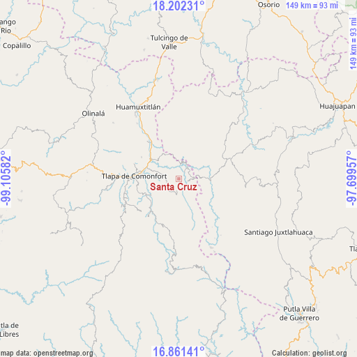
Santa Cruz GPS coordinates[2]
17° 31' 59.16" North, 98° 24' 9.684" West
| Map corner | latitude | longitude |
|---|---|---|
| Upper-left | 18.20231°, | -99.10582° |
| Center: | 17.5331°, | -98.40269° |
| Lower-right: | 16.86141°, | -97.69957° |
| Map W x H: | 149.1×149.1 km | = 92.6×92.6mi |
| max Lat: | 32.7° ⇑82.8% North |
| Santa Cruz: | 17.5331° |
| min Lat: | ⇓17.2% South 14.53588° |
| min Long | Santa Cruz | max Long |
| -117.105° | -98.40269° | -86.73105° |
| W 58.6%⇐ | ⇒41.4% E |
Elevation
Elevation of Santa Cruz is 1660 m = 5446 ft, and this is 406.3 m = 1333 ft above average elevation for this country.
| Max E: |
3497 m = 11473 ft | 43% |
| Santa Cruz | 1660 m 5446 ft | |
| Avg. | 1253.7 m = 4113 ft | |
Min E: |
-1 m = -3 ft | 57% |
See also: Mexico elevation on elevation.city.
Geographical zone
Santa Cruz is located in North Torrid zone (between Equator and Tropic of Cancer). Distance of this Northern Tropic circle is 656.4 km =407.9 mi to North.| Distance of | km | miles | from Santa Cruz |
|---|---|---|---|
| North Pole | 8057.6 | 5006.8 | to North |
| Arctic Circle | 5451.7 | 3387.5 | to North |
| Tropic Cancer | 656.4 | 407.9 | to North |
| Equator | 1949.5 | 1211.4 | to South |


Nearby cities:
15 places around Santa Cruz: (largest is in red/bold)
• Alcozauca de Guerrero
7.8 km =4.8 mi,  165°
165°
• Almolonga de Ocampo (Almolonga)
13.6 km =8.5 mi,  157°
157°
• Calihualá
13.2 km =8.2 mi,  90°
90°
• Cuba Libre
11.7 km =7.3 mi,  239°
239°
• Cuyuxtlahuaca
8.4 km =5.2 mi,  132°
132°
• El Platanar (Santa María Guadalupe el Platanar)
12.1 km =7.5 mi,  245°
245°
• Guadalupe Nogales
11.7 km =7.3 mi,  120°
120°
• Igualita
14.5 km =9 mi, 236°
• La Luz de Juárez
5.8 km =3.6 mi, 87°
• San Mateo Nejápam
13.7 km =8.5 mi,  353°
353°
• Tecoyame de Guadalupe
11.4 km =7.1 mi,  332°
332°
• Tepetlapa
14.8 km =9.2 mi,  4°
4°
• Tlachichilco
11.7 km =7.3 mi,  32°
32°
• Tlalixtaquilla
6.1 km =3.8 mi,  37°
37°
• Xonacatlán
3.6 km =2.2 mi,  196°
196°
Sources, notices
• [Note1] Compared only with cities in Mexico existing in our database
• [Src1] Map data: © OpenStreetMap contributors (CC-BY-SA)
• [Src2] Other city data from geonames.org with taken over terms of usage.
• [Src3] Geographical zone / Annual Mean Temperature by Robert A. Rohde @ Wikipedia
