Zumpango geodata
Zumpango (Guerrero) is a populated place; located in Mexico in America/Mexico_City (GMT-6) time zone. With population of 1,144 people, there are 7588 cities with bigger population in this country. Compared to other cities in Mexico, 79.3% of cities are located further ↑North; 55.3% of cities are located further ←West and 55.7% of cities have higher elevation than Zumpango. Note1


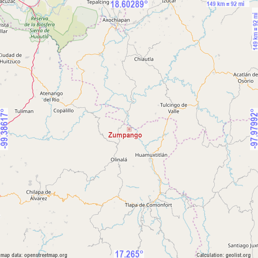
Zumpango GPS coordinates[2]
17° 56' 6.756" North, 98° 40' 58.944" West
| Map corner | latitude | longitude |
|---|---|---|
| Upper-left | 18.60289°, | -99.38617° |
| Center: | 17.93521°, | -98.68304° |
| Lower-right: | 17.265°, | -97.97992° |
| Map W x H: | 148.8×148.8 km | = 92.5×92.5mi |
| max Lat: | 32.7° ⇑79.3% North |
| Zumpango: | 17.93521° |
| min Lat: | ⇓20.7% South 14.53588° |
| min Long | Zumpango | max Long |
| -117.105° | -98.68304° | -86.73105° |
| W 55.3%⇐ | ⇒44.7% E |
Elevation
Elevation of Zumpango is 1172 m = 3845 ft, and this is 81.7 m = 268 ft below average elevation for this country.
| Max E: |
3497 m = 11473 ft | 55.7% |
| Avg. | 1253.7 m = 4113 ft | |
| Zumpango | 1172 m = 3845 ft | |
Min E: |
-1 m = -3 ft | 44.3% |
See also: Mexico elevation on elevation.city.
Geographical zone
Zumpango is located in North Torrid zone (between Equator and Tropic of Cancer). Distance of this Northern Tropic circle is 611.7 km =380.1 mi to North.| Distance of | km | miles | from Zumpango |
|---|---|---|---|
| North Pole | 8012.9 | 4979 | to North |
| Arctic Circle | 5407 | 3359.8 | to North |
| Tropic Cancer | 611.7 | 380.1 | to North |
| Equator | 1994.2 | 1239.1 | to South |


Nearby cities:
15 places around Zumpango: (largest is in red/bold)
• Acaxtlahuacán de Albino Zertuche
17.6 km =10.9 mi,  58°
58°
• Ahuacatlán
4.7 km =2.9 mi,  238°
238°
• Amatlicha
17.5 km =10.9 mi,  226°
226°
• Chiaucingo
21.5 km =13.4 mi,  183°
183°
• Coacalco
15.2 km =9.4 mi,  6°
6°
• Cualác
21.5 km =13.4 mi,  173°
173°
• Huamuxtitlán
19.2 km =11.9 mi,  139°
139°
• Ixcamilpa
10.4 km =6.5 mi,  352°
352°
• Olinalá
18.4 km =11.4 mi,  198°
198°
• San Antonio Coyahuacán
8.2 km =5.1 mi, 177°
• San Miguel Comitlipa
14.3 km =8.9 mi,  76°
76°
• Santa Cruz Lomalapa (Lomalapa)
2.5 km =1.6 mi,  150°
150°
• Tepetlacingo
8.6 km =5.3 mi,  259°
259°
• Toltecamila
7.5 km =4.7 mi,  66°
66°
• Xochihuehuetlán
20.9 km =13 mi,  98°
98°
Sources, notices
• [Note1] Compared only with cities in Mexico existing in our database
• [Src1] Map data: © OpenStreetMap contributors (CC-BY-SA)
• [Src2] Other city data from geonames.org with taken over terms of usage.
• [Src3] Geographical zone / Annual Mean Temperature by Robert A. Rohde @ Wikipedia
