Coacalco geodata
Coacalco (Puebla) is a populated place; located in Mexico in America/Mexico_City (GMT-6) time zone. With population of 519 people, there are 16226 cities with bigger population in this country. Compared to other cities in Mexico, 77.9% of cities are located further ↑North; 55.4% of cities are located further ←West and 64.5% of cities have higher elevation than Coacalco. Note1


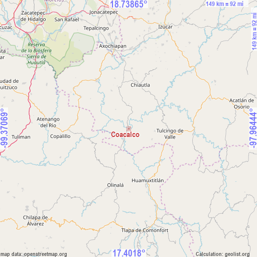
Coacalco GPS coordinates[2]
18° 4' 17.4" North, 98° 40' 3.216" West
| Map corner | latitude | longitude |
|---|---|---|
| Upper-left | 18.73865°, | -99.37069° |
| Center: | 18.0715°, | -98.66756° |
| Lower-right: | 17.4018°, | -97.96444° |
| Map W x H: | 148.6×148.6 km | = 92.3×92.3mi |
| max Lat: | 32.7° ⇑77.9% North |
| Coacalco: | 18.0715° |
| min Lat: | ⇓22.1% South 14.53588° |
| min Long | Coacalco | max Long |
| -117.105° | -98.66756° | -86.73105° |
| W 55.4%⇐ | ⇒44.6% E |
Elevation
Elevation of Coacalco is 715 m = 2346 ft, and this is 538.7 m = 1767 ft below average elevation for this country.
| Max E: |
3497 m = 11473 ft | 64.5% |
| Avg. | 1253.7 m = 4113 ft | |
| Coacalco | 715 m = 2346 ft | |
Min E: |
-1 m = -3 ft | 35.5% |
See also: Mexico elevation on elevation.city.
Geographical zone
Coacalco is located in North Torrid zone (between Equator and Tropic of Cancer). Distance of this Northern Tropic circle is 596.6 km =370.7 mi to North.| Distance of | km | miles | from Coacalco |
|---|---|---|---|
| North Pole | 7997.7 | 4969.5 | to North |
| Arctic Circle | 5391.8 | 3350.3 | to North |
| Tropic Cancer | 596.6 | 370.7 | to North |
| Equator | 2009.4 | 1248.6 | to South |


Nearby cities:
15 places around Coacalco: (largest is in red/bold)
• Acaxtlahuacán de Albino Zertuche
14.8 km =9.2 mi,  114°
114°
• Ahuacatlán
18.5 km =11.5 mi,  197°
197°
• Ayoxuxtla
24.1 km =15 mi,  335°
335°
• Chila de la Sal
19.7 km =12.2 mi,  77°
77°
• Ixcamilpa
5.7 km =3.5 mi,  212°
212°
• Pilcaya (San Juan Pilcaya)
18.9 km =11.7 mi,  347°
347°
• San Antonio Coyahuacán
23.3 km =14.5 mi,  183°
183°
• San Miguel Comitlipa
17 km =10.6 mi,  134°
134°
• Santa Cruz Lomalapa (Lomalapa)
17.4 km =10.8 mi, 181°
• Santa Mónica
21 km =13 mi,  316°
316°
• Tepetlacingo
19.6 km =12.2 mi, 210°
• Toltecamila
13.2 km =8.2 mi,  156°
156°
• Tulcingo de Valle
24.2 km =15 mi,  97°
97°
• Xicotlán
15.2 km =9.4 mi, 95°
• Zumpango
15.2 km =9.4 mi,  186°
186°
Sources, notices
• [Note1] Compared only with cities in Mexico existing in our database
• [Src1] Map data: © OpenStreetMap contributors (CC-BY-SA)
• [Src2] Other city data from geonames.org with taken over terms of usage.
• [Src3] Geographical zone / Annual Mean Temperature by Robert A. Rohde @ Wikipedia
