San Miguel Comitlipa geodata
San Miguel Comitlipa (Guerrero) is a populated place; located in Mexico in America/Mexico_City (GMT-6) time zone. With population of 857 people, there are 10207 cities with bigger population in this country. Compared to other cities in Mexico, 79.1% of cities are located further ↑North; 56.6% of cities are located further ←West and 53.1% of cities have higher elevation than San Miguel Comitlipa. Note1
Current local time in San Miguel Comitlipa:
07:02 AM, WednesdayDifference from your time zone: hours


San Miguel Comitlipa GPS coordinates[2]
17° 57' 54.684" North, 98° 33' 7.164" West
| Map corner | latitude | longitude |
|---|---|---|
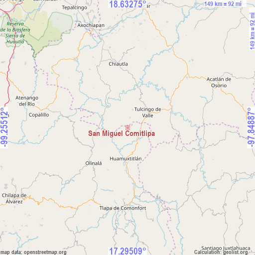
| Upper-left | 18.63275°, | -99.25512° |
| Center: | 17.96519°, | -98.55199° |
| Lower-right: | 17.29509°, | -97.84887° |
| Map W x H: | 148.7×148.7 km | = 92.4×92.4mi |
| max Lat: | 32.7° ⇑79.1% North |
| San Miguel Comitlipa: | 17.96519° |
| min Lat: | ⇓20.9% South 14.53588° |
| min Long | San Miguel Comi | max Long |
| -117.105° | -98.55199° | -86.73105° |
| W 56.6%⇐ | ⇒43.4% E |
Elevation
Elevation of San Miguel Comitlipa is 1285 m = 4216 ft, and this is 31.3 m = 103 ft above average elevation for this country.
| Max E: |
3497 m = 11473 ft | 53.1% |
| San Miguel Comitlipa | 1285 m 4216 ft | |
| Avg. | 1253.7 m = 4113 ft | |
Min E: |
-1 m = -3 ft | 46.9% |
See also: Mexico elevation on elevation.city.
Geographical zone
San Miguel Comitlipa is located in North Torrid zone (between Equator and Tropic of Cancer). Distance of this Northern Tropic circle is 608.4 km =378 mi to North.| Distance of | km | miles | from San Miguel Comitlipa |
|---|---|---|---|
| North Pole | 8009.5 | 4976.9 | to North |
| Arctic Circle | 5403.6 | 3357.6 | to North |
| Tropic Cancer | 608.4 | 378 | to North |
| Equator | 1997.5 | 1241.2 | to South |


Nearby cities:
15 places around San Miguel Comitlipa: (largest is in red/bold)
• Acaxtlahuacán de Albino Zertuche
5.9 km =3.7 mi,  12°
12°
• Chila de la Sal
17.5 km =10.9 mi,  23°
23°
• Coacalco
17 km =10.6 mi,  314°
314°
• Guadalupe Victoria
17.6 km =10.9 mi,  85°
85°
• Huamuxtitlán
17.9 km =11.1 mi,  184°
184°
• Ixcamilpa
16.8 km =10.4 mi,  294°
294°
• San Antonio Coyahuacán
17.8 km =11.1 mi,  229°
229°
• San Miguel Tlaltepexi
14.7 km =9.1 mi,  112°
112°
• Santa Cruz Lomalapa (Lomalapa)
13.8 km =8.6 mi,  246°
246°
• Toltecamila
7 km =4.3 mi,  267°
267°
• Tulcingo de Valle
14.6 km =9.1 mi,  53°
53°
• Xicotlán
10.8 km =6.7 mi, 15°
• Xixingo de los Reyes
17.3 km =10.7 mi,  117°
117°
• Xochihuehuetlán
9.4 km =5.8 mi,  134°
134°
• Zumpango
14.3 km =8.9 mi,  256°
256°
Sources, notices
• [Note1] Compared only with cities in Mexico existing in our database
• [Src1] Map data: © OpenStreetMap contributors (CC-BY-SA)
• [Src2] Other city data from geonames.org with taken over terms of usage.
• [Src3] Geographical zone / Annual Mean Temperature by Robert A. Rohde @ Wikipedia
