San Lucas geodata
San Lucas (Chiapas) is a populated place; located in Mexico in America/Mexico_City (GMT-6) time zone. With population of 4,716 people, there are 1956 cities with bigger population in this country. Compared to other cities in Mexico, 93.5% of cities are located further ↑North; 90.4% of cities are located further ←West and 65.4% of cities have higher elevation than San Lucas. Note1


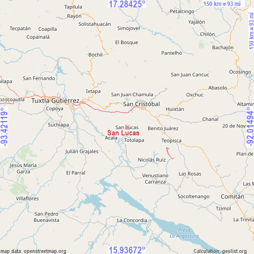
San Lucas GPS coordinates[2]
16° 36' 42.012" North, 92° 43' 5.016" West
| Map corner | latitude | longitude |
|---|---|---|
| Upper-left | 17.28425°, | -93.42119° |
| Center: | 16.61167°, | -92.71806° |
| Lower-right: | 15.93672°, | -92.01494° |
| Map W x H: | 149.8×149.8 km | = 93.1×93.1mi |
| max Lat: | 32.7° ⇑93.5% North |
| San Lucas: | 16.61167° |
| min Lat: | ⇓6.5% South 14.53588° |
| min Long | San Lucas | max Long |
| -117.105° | -92.71806° | -86.73105° |
| W 90.4%⇐ | ⇒9.6% E |
Elevation
Elevation of San Lucas is 665 m = 2182 ft, and this is 588.7 m = 1931 ft below average elevation for this country.
| Max E: |
3497 m = 11473 ft | 65.4% |
| Avg. | 1253.7 m = 4113 ft | |
| San Lucas | 665 m = 2182 ft | |
Min E: |
-1 m = -3 ft | 34.6% |
See also: Mexico elevation on elevation.city.
Geographical zone
San Lucas is located in North Torrid zone (between Equator and Tropic of Cancer). Distance of this Northern Tropic circle is 758.9 km =471.6 mi to North.| Distance of | km | miles | from San Lucas |
|---|---|---|---|
| North Pole | 8160 | 5070.4 | to North |
| Arctic Circle | 5554.1 | 3451.2 | to North |
| Tropic Cancer | 758.9 | 471.6 | to North |
| Equator | 1847 | 1147.7 | to South |


Nearby cities:
15 places around San Lucas: (largest is in red/bold)
• Acala
11.1 km =6.9 mi,  236°
236°
• Apas
13.6 km =8.5 mi,  323°
323°
• Bochojbo Alto
13.8 km =8.6 mi,  0°
0°
• Chiapilla
4.7 km =2.9 mi,  183°
183°
• Francisco Villa
4.9 km =3 mi,  117°
117°
• Jech Chentic
13.4 km =8.3 mi,  350°
350°
• Jechtoch
12.6 km =7.8 mi,  359°
359°
• Laguna del Carmen
4.3 km =2.7 mi,  16°
16°
• Lázaro Cárdenas
8.1 km =5 mi,  216°
216°
• Nachig
13.2 km =8.2 mi, 356°
• Pasté
10.6 km =6.6 mi, 346°
• San José Buenavista
1.8 km =1.1 mi,  310°
310°
• Shulvo
12.4 km =7.7 mi, 352°
• Totolapa
8.6 km =5.3 mi,  151°
151°
• Zacualpa Ecatepec
10.8 km =6.7 mi,  12°
12°
Sources, notices
• [Note1] Compared only with cities in Mexico existing in our database
• [Src1] Map data: © OpenStreetMap contributors (CC-BY-SA)
• [Src2] Other city data from geonames.org with taken over terms of usage.
• [Src3] Geographical zone / Annual Mean Temperature by Robert A. Rohde @ Wikipedia
