La Independencia geodata
La Independencia (Oaxaca) is a populated place; located in Mexico in America/Mexico_City (GMT-6) time zone. With population of 721 people, there are 12102 cities with bigger population in this country. Compared to other cities in Mexico, 92.9% of cities are located further ↑North; 68.2% of cities are located further ←West and 51.4% of cities have higher elevation than La Independencia. Note1


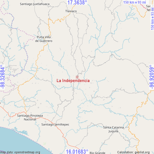
La Independencia GPS coordinates[2]
16° 41' 29.4" North, 97° 37' 25.356" West
| Map corner | latitude | longitude |
|---|---|---|
| Upper-left | 17.3638°, | -98.32684° |
| Center: | 16.6915°, | -97.62371° |
| Lower-right: | 16.01683°, | -96.92059° |
| Map W x H: | 149.8×149.8 km | = 93.1×93.1mi |
| max Lat: | 32.7° ⇑92.9% North |
| La Independencia: | 16.6915° |
| min Lat: | ⇓7.1% South 14.53588° |
| min Long | La Independenci | max Long |
| -117.105° | -97.62371° | -86.73105° |
| W 68.2%⇐ | ⇒31.8% E |
Elevation
Elevation of La Independencia is 1362 m = 4469 ft, and this is 108.3 m = 355 ft above average elevation for this country.
| Max E: |
3497 m = 11473 ft | 51.4% |
| La Independencia | 1362 m 4469 ft | |
| Avg. | 1253.7 m = 4113 ft | |
Min E: |
-1 m = -3 ft | 48.6% |
See also: Mexico elevation on elevation.city.
Geographical zone
La Independencia is located in North Torrid zone (between Equator and Tropic of Cancer). Distance of this Northern Tropic circle is 750 km =466 mi to North.| Distance of | km | miles | from La Independencia |
|---|---|---|---|
| North Pole | 8151.1 | 5064.9 | to North |
| Arctic Circle | 5545.3 | 3445.7 | to North |
| Tropic Cancer | 750 | 466 | to North |
| Equator | 1855.9 | 1153.2 | to South |


Nearby cities:
15 places around La Independencia: (largest is in red/bold)
• Colonia de Jesús (La Cucaracha)
16.1 km =10 mi,  109°
109°
• El Mosco
17 km =10.6 mi,  191°
191°
• Hidalgo
17.4 km =10.8 mi,  326°
326°
• La Humedad
13 km =8.1 mi,  200°
200°
• Llano Nuevo
15.9 km =9.9 mi,  129°
129°
• Llano Verde
17 km =10.6 mi, 200°
• Morelos
12.8 km =8 mi, 333°
• Piedra Grande
16.9 km =10.5 mi,  146°
146°
• Piedra del Tambor
11.4 km =7.1 mi, 108°
• Pueblo Viejo
15.7 km =9.8 mi,  182°
182°
• San Mateo Yucutindoo
15.8 km =9.8 mi,  71°
71°
• San Sebastián Yutanino
20.5 km =12.7 mi,  57°
57°
• Santiago Amoltepec
14.6 km =9.1 mi, 111°
• Santiago Ixtayutla
14.2 km =8.8 mi, 192°
• Zaragoza
18.2 km =11.3 mi,  262°
262°
Sources, notices
• [Note1] Compared only with cities in Mexico existing in our database
• [Src1] Map data: © OpenStreetMap contributors (CC-BY-SA)
• [Src2] Other city data from geonames.org with taken over terms of usage.
• [Src3] Geographical zone / Annual Mean Temperature by Robert A. Rohde @ Wikipedia
