Zaragoza geodata
Zaragoza (Oaxaca) is a populated place; located in Mexico in America/Mexico_City (GMT-6) time zone. With population of 1,386 people, there are 6243 cities with bigger population in this country. Compared to other cities in Mexico, 93.1% of cities are located further ↑North; 66.2% of cities are located further ←West and 62% of cities have lower elevation than Zaragoza. Note1


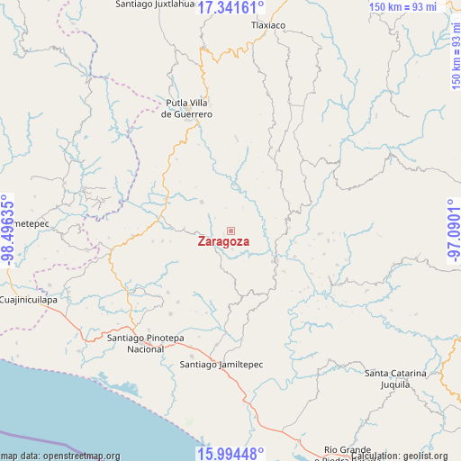
Zaragoza GPS coordinates[2]
16° 40' 9.228" North, 97° 47' 35.592" West
| Map corner | latitude | longitude |
|---|---|---|
| Upper-left | 17.34161°, | -98.49635° |
| Center: | 16.66923°, | -97.79322° |
| Lower-right: | 15.99448°, | -97.0901° |
| Map W x H: | 149.8×149.8 km | = 93.1×93.1mi |
| max Lat: | 32.7° ⇑93.1% North |
| Zaragoza: | 16.66923° |
| min Lat: | ⇓6.9% South 14.53588° |
| min Long | Zaragoza | max Long |
| -117.105° | -97.79322° | -86.73105° |
| W 66.2%⇐ | ⇒33.8% E |
Elevation
Elevation of Zaragoza is 1759 m = 5771 ft, and this is 505.3 m = 1658 ft above average elevation for this country.
| Max E: |
3497 m = 11473 ft | 38% |
| Zaragoza | 1759 m 5771 ft | |
| Avg. | 1253.7 m = 4113 ft | |
Min E: |
-1 m = -3 ft | 62% |
See also: Mexico elevation on elevation.city.
Geographical zone
Zaragoza is located in North Torrid zone (between Equator and Tropic of Cancer). Distance of this Northern Tropic circle is 752.5 km =467.6 mi to North.| Distance of | km | miles | from Zaragoza |
|---|---|---|---|
| North Pole | 8153.6 | 5066.4 | to North |
| Arctic Circle | 5547.7 | 3447.2 | to North |
| Tropic Cancer | 752.5 | 467.6 | to North |
| Equator | 1853.4 | 1151.6 | to South |


Nearby cities:
15 places around Zaragoza: (largest is in red/bold)
• Asunción Atoyaquillo
15.1 km =9.4 mi,  4°
4°
• El Carasol
17.4 km =10.8 mi,  175°
175°
• El Frutillo
19.6 km =12.2 mi,  174°
174°
• Guadalupe Nuevo Centro
18.3 km =11.4 mi,  320°
320°
• Hidalgo
18.9 km =11.7 mi,  26°
26°
• La Humedad
16.5 km =10.3 mi,  125°
125°
• La Independencia
18.2 km =11.3 mi,  82°
82°
• La Reforma
7.5 km =4.7 mi,  227°
227°
• Llano Verde
18 km =11.2 mi,  138°
138°
• Morelos
18.7 km =11.6 mi,  41°
41°
• Nuevo Progreso
19.6 km =12.2 mi,  213°
213°
• San Juan Cabeza del Río
13.3 km =8.3 mi,  314°
314°
• Santa Cruz Tutiahua
16.7 km =10.4 mi, 311°
• Santiago Ixtayutla
18.8 km =11.7 mi, 127°
• Villa Nueva
12.4 km =7.7 mi,  195°
195°
Sources, notices
• [Note1] Compared only with cities in Mexico existing in our database
• [Src1] Map data: © OpenStreetMap contributors (CC-BY-SA)
• [Src2] Other city data from geonames.org with taken over terms of usage.
• [Src3] Geographical zone / Annual Mean Temperature by Robert A. Rohde @ Wikipedia
