Hidalgo geodata
Hidalgo (Oaxaca) is a populated place; located in Mexico in America/Mexico_City (GMT-6) time zone. With population of 649 people, there are 13347 cities with bigger population in this country. Compared to other cities in Mexico, 91.4% of cities are located further ↑North; 67.1% of cities are located further ←West and 56.4% of cities have higher elevation than Hidalgo. Note1


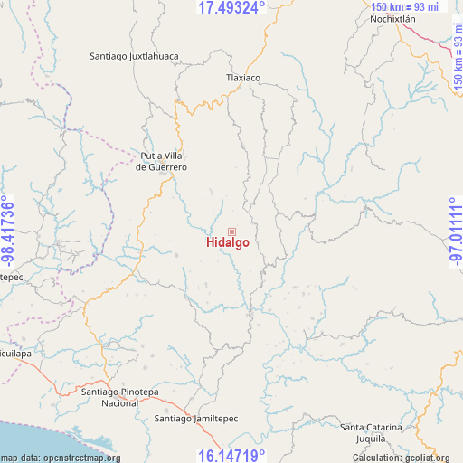
Hidalgo GPS coordinates[2]
16° 49' 17.076" North, 97° 42' 51.228" West
| Map corner | latitude | longitude |
|---|---|---|
| Upper-left | 17.49324°, | -98.41736° |
| Center: | 16.82141°, | -97.71423° |
| Lower-right: | 16.14719°, | -97.01111° |
| Map W x H: | 149.7×149.7 km | = 93×93mi |
| max Lat: | 32.7° ⇑91.4% North |
| Hidalgo: | 16.82141° |
| min Lat: | ⇓8.6% South 14.53588° |
| min Long | Hidalgo | max Long |
| -117.105° | -97.71423° | -86.73105° |
| W 67.1%⇐ | ⇒32.9% E |
Elevation
Elevation of Hidalgo is 1143 m = 3750 ft, and this is 110.7 m = 363 ft below average elevation for this country.
| Max E: |
3497 m = 11473 ft | 56.4% |
| Avg. | 1253.7 m = 4113 ft | |
| Hidalgo | 1143 m = 3750 ft | |
Min E: |
-1 m = -3 ft | 43.6% |
See also: Mexico elevation on elevation.city.
Geographical zone
Hidalgo is located in North Torrid zone (between Equator and Tropic of Cancer). Distance of this Northern Tropic circle is 735.6 km =457.1 mi to North.| Distance of | km | miles | from Hidalgo |
|---|---|---|---|
| North Pole | 8136.7 | 5055.9 | to North |
| Arctic Circle | 5530.8 | 3436.7 | to North |
| Tropic Cancer | 735.6 | 457.1 | to North |
| Equator | 1870.4 | 1162.2 | to South |


Nearby cities:
15 places around Hidalgo: (largest is in red/bold)
• Agua del Toro
19 km =11.8 mi,  359°
359°
• Aldama
20.4 km =12.7 mi,  38°
38°
• Asunción Atoyaquillo
7.6 km =4.7 mi,  256°
256°
• Guadalupe Nuevo Centro
20.2 km =12.6 mi, 262°
• Imperio
16.4 km =10.2 mi,  49°
49°
• La Independencia
17.4 km =10.8 mi,  146°
146°
• Morelos
5 km =3.1 mi,  126°
126°
• San Juan Cabeza del Río
19.5 km =12.1 mi,  246°
246°
• San Sebastián Nopalera
15.1 km =9.4 mi,  333°
333°
• Santa Cruz Itundujia
8.2 km =5.1 mi, 44°
• Santa María Ocotlán
15.8 km =9.8 mi,  353°
353°
• Santiago Yosondúa
15.9 km =9.9 mi,  67°
67°
• Yutecoso Cuauhtémoc
11.4 km =7.1 mi,  7°
7°
• Zaragoza
18.9 km =11.7 mi,  206°
206°
• Zimatlán
18 km =11.2 mi,  316°
316°
Sources, notices
• [Note1] Compared only with cities in Mexico existing in our database
• [Src1] Map data: © OpenStreetMap contributors (CC-BY-SA)
• [Src2] Other city data from geonames.org with taken over terms of usage.
• [Src3] Geographical zone / Annual Mean Temperature by Robert A. Rohde @ Wikipedia
