Llano Verde geodata
Llano Verde (Oaxaca) is a populated place; located in Mexico in America/Mexico_City (GMT-6) time zone. With population of 545 people, there are 15598 cities with bigger population in this country. Compared to other cities in Mexico, 94% of cities are located further ↑North; 67.5% of cities are located further ←West and 63.6% of cities have higher elevation than Llano Verde. Note1


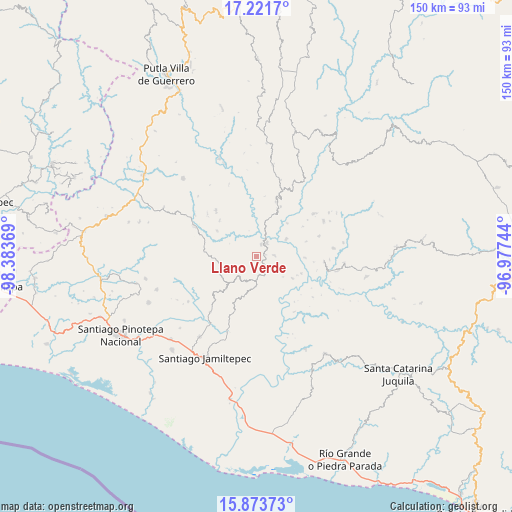
Llano Verde GPS coordinates[2]
16° 32' 56.004" North, 97° 40' 50.016" West
| Map corner | latitude | longitude |
|---|---|---|
| Upper-left | 17.2217°, | -98.38369° |
| Center: | 16.54889°, | -97.68056° |
| Lower-right: | 15.87373°, | -96.97744° |
| Map W x H: | 149.9×149.9 km | = 93.1×93.1mi |
| max Lat: | 32.7° ⇑94% North |
| Llano Verde: | 16.54889° |
| min Lat: | ⇓6% South 14.53588° |
| min Long | Llano Verde | max Long |
| -117.105° | -97.68056° | -86.73105° |
| W 67.5%⇐ | ⇒32.5% E |
Elevation
Elevation of Llano Verde is 778 m = 2552 ft, and this is 475.7 m = 1561 ft below average elevation for this country.
| Max E: |
3497 m = 11473 ft | 63.6% |
| Avg. | 1253.7 m = 4113 ft | |
| Llano Verde | 778 m = 2552 ft | |
Min E: |
-1 m = -3 ft | 36.4% |
See also: Mexico elevation on elevation.city.
Geographical zone
Llano Verde is located in North Torrid zone (between Equator and Tropic of Cancer). Distance of this Northern Tropic circle is 765.9 km =475.9 mi to North.| Distance of | km | miles | from Llano Verde |
|---|---|---|---|
| North Pole | 8167 | 5074.7 | to North |
| Arctic Circle | 5561.1 | 3455.5 | to North |
| Tropic Cancer | 765.9 | 475.9 | to North |
| Equator | 1840.1 | 1143.4 | to South |


Nearby cities:
15 places around Llano Verde: (largest is in red/bold)
• El Carasol
11.4 km =7.1 mi,  249°
249°
• El Frutillo
11.8 km =7.3 mi,  238°
238°
• El Limoncillo
18.5 km =11.5 mi,  98°
98°
• El Mosco
2.8 km =1.7 mi,  106°
106°
• La Humedad
4 km =2.5 mi,  20°
20°
• La Independencia
17 km =10.6 mi, 20°
• La Muralla
18.2 km =11.3 mi, 249°
• Llano Nuevo
19.3 km =12 mi,  72°
72°
• Piedra Grande
15.5 km =9.6 mi,  83°
83°
• Pueblo Viejo
5.4 km =3.4 mi,  88°
88°
• Quinicuena
16.8 km =10.4 mi, 96°
• San José de las Flores
17.6 km =10.9 mi,  202°
202°
• Santiago Ixtayutla
3.5 km =2.2 mi,  56°
56°
• Villa Nueva
15.4 km =9.6 mi,  275°
275°
• Zaragoza
18 km =11.2 mi,  318°
318°
Sources, notices
• [Note1] Compared only with cities in Mexico existing in our database
• [Src1] Map data: © OpenStreetMap contributors (CC-BY-SA)
• [Src2] Other city data from geonames.org with taken over terms of usage.
• [Src3] Geographical zone / Annual Mean Temperature by Robert A. Rohde @ Wikipedia
