Santa Rosa Matagallinas geodata
Santa Rosa Matagallinas (Oaxaca) is a populated place; located in Mexico in America/Mexico_City (GMT-6) time zone. With population of 622 people, there are 13890 cities with bigger population in this country. Compared to other cities in Mexico, 93.7% of cities are located further ↑North; 74.6% of cities are located further ←West and 50.8% of cities have lower elevation than Santa Rosa Matagallinas. Note1
Current local time in Santa Rosa Matagallinas:
01:42 PM, MondayDifference from your time zone: hours


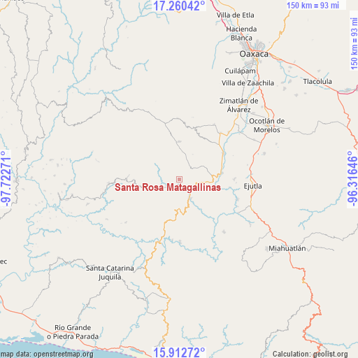
Santa Rosa Matagallinas GPS coordinates[2]
16° 35' 15.9" North, 97° 1' 10.488" West
| Map corner | latitude | longitude |
|---|---|---|
| Upper-left | 17.26042°, | -97.72271° |
| Center: | 16.58775°, | -97.01958° |
| Lower-right: | 15.91272°, | -96.31646° |
| Map W x H: | 149.9×149.9 km | = 93.1×93.1mi |
| max Lat: | 32.7° ⇑93.7% North |
| Santa Rosa Matagallinas: | 16.58775° |
| min Lat: | ⇓6.3% South 14.53588° |
| min Long | Santa Rosa Mata | max Long |
| -117.105° | -97.01958° | -86.73105° |
| W 74.6%⇐ | ⇒25.4% E |
Elevation
Elevation of Santa Rosa Matagallinas is 1477 m = 4846 ft, and this is 223.3 m = 733 ft above average elevation for this country.
| Max E: |
3497 m = 11473 ft | 49.2% |
| Santa Rosa Matagallinas | 1477 m 4846 ft | |
| Avg. | 1253.7 m = 4113 ft | |
Min E: |
-1 m = -3 ft | 50.8% |
See also: Mexico elevation on elevation.city.
Geographical zone
Santa Rosa Matagallinas is located in North Torrid zone (between Equator and Tropic of Cancer). Distance of this Northern Tropic circle is 761.5 km =473.2 mi to North.| Distance of | km | miles | from Santa Rosa Matagallinas |
|---|---|---|---|
| North Pole | 8162.7 | 5072.1 | to North |
| Arctic Circle | 5556.8 | 3452.8 | to North |
| Tropic Cancer | 761.5 | 473.2 | to North |
| Equator | 1844.4 | 1146.1 | to South |


Nearby cities:
15 places around Santa Rosa Matagallinas: (largest is in red/bold)
• Agua Fría Campanario
20.6 km =12.8 mi,  33°
33°
• Ayoquezco de Aldama
21.6 km =13.4 mi,  60°
60°
• El Arador
18.1 km =11.2 mi,  253°
253°
• La Compañía
21.6 km =13.4 mi,  98°
98°
• San Andrés Zabache
17.3 km =10.7 mi,  85°
85°
• San Francisco Sola
9.3 km =5.8 mi,  149°
149°
• San Martín Lachila
18.4 km =11.4 mi,  81°
81°
• San Sebastián de las Grutas
8.3 km =5.2 mi,  53°
53°
• San Vicente Lachixío
13 km =8.1 mi,  0°
0°
• Santa Cruz Nexila
18.8 km =11.7 mi,  73°
73°
• Santa María Lachixío
15.5 km =9.6 mi, 0°
• Santa María Sola
2.5 km =1.6 mi,  163°
163°
• Teojomulco
21.9 km =13.6 mi,  270°
270°
• Texmelucan
19.1 km =11.9 mi, 269°
• Villa Sola de Vega
8.9 km =5.5 mi, 150°
Sources, notices
• [Note1] Compared only with cities in Mexico existing in our database
• [Src1] Map data: © OpenStreetMap contributors (CC-BY-SA)
• [Src2] Other city data from geonames.org with taken over terms of usage.
• [Src3] Geographical zone / Annual Mean Temperature by Robert A. Rohde @ Wikipedia
