Villa Sola de Vega geodata
Villa Sola de Vega (Oaxaca) is a populated place; located in Mexico in America/Mexico_City (GMT-6) time zone. With population of 1,846 people, there are 4705 cities with bigger population in this country. Compared to other cities in Mexico, 94.2% of cities are located further ↑North; 75.1% of cities are located further ←West and 50.2% of cities have lower elevation than Villa Sola de Vega. Note1


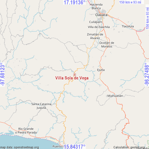
Villa Sola de Vega GPS coordinates[2]
16° 31' 6.384" North, 96° 58' 41.16" West
| Map corner | latitude | longitude |
|---|---|---|
| Upper-left | 17.19136°, | -97.68123° |
| Center: | 16.51844°, | -96.9781° |
| Lower-right: | 15.84317°, | -96.27498° |
| Map W x H: | 149.9×149.9 km | = 93.1×93.1mi |
| max Lat: | 32.7° ⇑94.2% North |
| Villa Sola de Vega: | 16.51844° |
| min Lat: | ⇓5.8% South 14.53588° |
| min Long | Villa Sola de V | max Long |
| -117.105° | -96.9781° | -86.73105° |
| W 75.1%⇐ | ⇒24.9% E |
Elevation
Elevation of Villa Sola de Vega is 1443 m = 4734 ft, and this is 189.3 m = 621 ft above average elevation for this country.
| Max E: |
3497 m = 11473 ft | 49.8% |
| Villa Sola de Vega | 1443 m 4734 ft | |
| Avg. | 1253.7 m = 4113 ft | |
Min E: |
-1 m = -3 ft | 50.2% |
See also: Mexico elevation on elevation.city.
Geographical zone
Villa Sola de Vega is located in North Torrid zone (between Equator and Tropic of Cancer). Distance of this Northern Tropic circle is 769.2 km =478 mi to North.| Distance of | km | miles | from Villa Sola de Vega |
|---|---|---|---|
| North Pole | 8170.4 | 5076.8 | to North |
| Arctic Circle | 5564.5 | 3457.6 | to North |
| Tropic Cancer | 769.2 | 478 | to North |
| Equator | 1836.7 | 1141.3 | to South |


Nearby cities:
15 places around Villa Sola de Vega: (largest is in red/bold)
• Agua del Espino
20.4 km =12.7 mi,  66°
66°
• El Arador
21.9 km =13.6 mi,  276°
276°
• La Compañía
17.5 km =10.9 mi,  75°
75°
• San Agustín Amatengo
20.2 km =12.6 mi,  92°
92°
• San Andrés Zabache
15.7 km =9.8 mi,  54°
54°
• San Cristóbal Honduras
22.5 km =14 mi,  197°
197°
• San Francisco Sola
0.4 km =0.2 mi,  130°
130°
• San Martín Lachila
17.3 km =10.7 mi, 52°
• San Sebastián de las Grutas
12.8 km =8 mi,  9°
9°
• San Vicente Coatlán
20.3 km =12.6 mi,  135°
135°
• San Vicente Lachixío
21.2 km =13.2 mi,  348°
348°
• Santa Cruz Nexila
18.7 km =11.6 mi, 46°
• Santa María Sola
6.5 km =4 mi,  324°
324°
• Santa Rosa Matagallinas
8.9 km =5.5 mi,  330°
330°
• Santiago Yogana
21.3 km =13.2 mi,  107°
107°
Sources, notices
• [Note1] Compared only with cities in Mexico existing in our database
• [Src1] Map data: © OpenStreetMap contributors (CC-BY-SA)
• [Src2] Other city data from geonames.org with taken over terms of usage.
• [Src3] Geographical zone / Annual Mean Temperature by Robert A. Rohde @ Wikipedia
