San Sebastián de las Grutas geodata
San Sebastián de las Grutas (Oaxaca) is a populated place; located in Mexico in America/Mexico_City (GMT-6) time zone. With population of 926 people, there are 9423 cities with bigger population in this country. Compared to other cities in Mexico, 93.4% of cities are located further ↑North; 75.5% of cities are located further ←West and 59% of cities have lower elevation than San Sebastián de las Grutas. Note1
Current local time in San Sebastián de las Grutas:
01:40 PM, MondayDifference from your time zone: hours


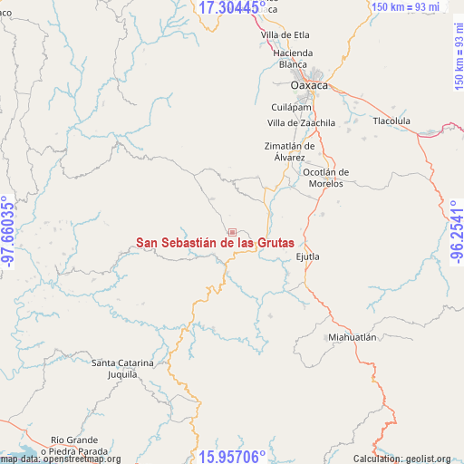
San Sebastián de las Grutas GPS coordinates[2]
16° 37' 54.984" North, 96° 57' 25.992" West
| Map corner | latitude | longitude |
|---|---|---|
| Upper-left | 17.30445°, | -97.66035° |
| Center: | 16.63194°, | -96.95722° |
| Lower-right: | 15.95706°, | -96.2541° |
| Map W x H: | 149.8×149.8 km | = 93.1×93.1mi |
| max Lat: | 32.7° ⇑93.4% North |
| San Sebastián de las Grutas: | 16.63194° |
| min Lat: | ⇓6.6% South 14.53588° |
| min Long | San Sebastián | max Long |
| -117.105° | -96.95722° | -86.73105° |
| W 75.5%⇐ | ⇒24.5% E |
Elevation
Elevation of San Sebastián de las Grutas is 1708 m = 5604 ft, and this is 454.3 m = 1490 ft above average elevation for this country.
| Max E: |
3497 m = 11473 ft | 41% |
| San Sebastián de las Grutas | 1708 m 5604 ft | |
| Avg. | 1253.7 m = 4113 ft | |
Min E: |
-1 m = -3 ft | 59% |
See also: Mexico elevation on elevation.city.
Geographical zone
San Sebastián de las Grutas is located in North Torrid zone (between Equator and Tropic of Cancer). Distance of this Northern Tropic circle is 756.6 km =470.1 mi to North.| Distance of | km | miles | from San Sebastián de las Grutas |
|---|---|---|---|
| North Pole | 8157.8 | 5069 | to North |
| Arctic Circle | 5551.9 | 3449.8 | to North |
| Tropic Cancer | 756.6 | 470.1 | to North |
| Equator | 1849.3 | 1149.1 | to South |


Nearby cities:
15 places around San Sebastián de las Grutas: (largest is in red/bold)
• Agua Fría Campanario
13.1 km =8.1 mi,  21°
21°
• Ayoquezco de Aldama
13.5 km =8.4 mi,  64°
64°
• La Compañía
16.8 km =10.4 mi,  119°
119°
• La Pe
17 km =10.6 mi,  90°
90°
• San Andrés Zabache
11.2 km =7 mi,  108°
108°
• San Francisco Sola
13 km =8.1 mi,  188°
188°
• San Martín Lachila
11.8 km =7.3 mi,  100°
100°
• San Mateo Mixtepec
17 km =10.6 mi,  5°
5°
• San Miguel Mixtepec
16.2 km =10.1 mi,  359°
359°
• San Vicente Lachixío
10.4 km =6.5 mi,  321°
321°
• Santa Cruz Nexila
11.4 km =7.1 mi, 88°
• Santa María Lachixío
12.4 km =7.7 mi,  328°
328°
• Santa María Sola
9.4 km =5.8 mi,  219°
219°
• Santa Rosa Matagallinas
8.3 km =5.2 mi,  233°
233°
• Villa Sola de Vega
12.8 km =8 mi, 189°
Sources, notices
• [Note1] Compared only with cities in Mexico existing in our database
• [Src1] Map data: © OpenStreetMap contributors (CC-BY-SA)
• [Src2] Other city data from geonames.org with taken over terms of usage.
• [Src3] Geographical zone / Annual Mean Temperature by Robert A. Rohde @ Wikipedia
