Malpica geodata
Malpica (Oaxaca) is a populated place; located in Mexico in America/Mexico_City (GMT-6) time zone. With population of 765 people, there are 11448 cities with bigger population in this country. Compared to other cities in Mexico, 88.7% of cities are located further ↑North; 64.7% of cities are located further ←West and 64.1% of cities have higher elevation than Malpica. Note1


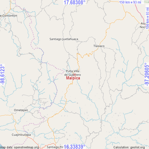
Malpica GPS coordinates[2]
17° 0' 42.984" North, 97° 54' 33.012" West
| Map corner | latitude | longitude |
|---|---|---|
| Upper-left | 17.68308°, | -98.6123° |
| Center: | 17.01194°, | -97.90917° |
| Lower-right: | 16.33839°, | -97.20605° |
| Map W x H: | 149.5×149.5 km | = 92.9×92.9mi |
| max Lat: | 32.7° ⇑88.7% North |
| Malpica: | 17.01194° |
| min Lat: | ⇓11.3% South 14.53588° |
| min Long | Malpica | max Long |
| -117.105° | -97.90917° | -86.73105° |
| W 64.7%⇐ | ⇒35.3% E |
Elevation
Elevation of Malpica is 741 m = 2431 ft, and this is 512.7 m = 1682 ft below average elevation for this country.
| Max E: |
3497 m = 11473 ft | 64.1% |
| Avg. | 1253.7 m = 4113 ft | |
| Malpica | 741 m = 2431 ft | |
Min E: |
-1 m = -3 ft | 35.9% |
See also: Mexico elevation on elevation.city.
Geographical zone
Malpica is located in North Torrid zone (between Equator and Tropic of Cancer). Distance of this Northern Tropic circle is 714.4 km =443.9 mi to North.| Distance of | km | miles | from Malpica |
|---|---|---|---|
| North Pole | 8115.5 | 5042.7 | to North |
| Arctic Circle | 5509.6 | 3423.5 | to North |
| Tropic Cancer | 714.4 | 443.9 | to North |
| Equator | 1891.6 | 1175.4 | to South |


Nearby cities:
15 places around Malpica: (largest is in red/bold)
• Concepción del Progreso
6.3 km =3.9 mi,  52°
52°
• Constancia del Rosario
4.5 km =2.8 mi,  310°
310°
• La Zafra
3.7 km =2.3 mi,  143°
143°
• Miramar
11.8 km =7.3 mi,  95°
95°
• Putla Villa de Guerrero
2.6 km =1.6 mi, 307°
• Río Metates
14.5 km =9 mi,  326°
326°
• San Juan Lagunas
2.8 km =1.7 mi,  234°
234°
• San Juan Teponaxtla
6 km =3.7 mi,  68°
68°
• San Miguel Copala
5.9 km =3.7 mi,  338°
338°
• San Miguel Reyes
10.2 km =6.3 mi,  170°
170°
• San Pedro Siniyuvi
7.9 km =4.9 mi,  112°
112°
• Santa María Yucuhiti
14.9 km =9.3 mi,  87°
87°
• Santiago Nuyoó
15.2 km =9.4 mi, 88°
• Tierra Blanca
15.3 km =9.5 mi,  359°
359°
• Zimatlán
11.6 km =7.2 mi,  134°
134°
Sources, notices
• [Note1] Compared only with cities in Mexico existing in our database
• [Src1] Map data: © OpenStreetMap contributors (CC-BY-SA)
• [Src2] Other city data from geonames.org with taken over terms of usage.
• [Src3] Geographical zone / Annual Mean Temperature by Robert A. Rohde @ Wikipedia
