Buenos Aires geodata
Buenos Aires (Oaxaca) is a populated place; located in Mexico in America/Mexico_City (GMT-6) time zone. With population of 653 people, there are 13279 cities with bigger population in this country. Compared to other cities in Mexico, 75.4% of cities are located further ↑North; 79.1% of cities are located further ←West and 80.9% of cities have higher elevation than Buenos Aires. Note1


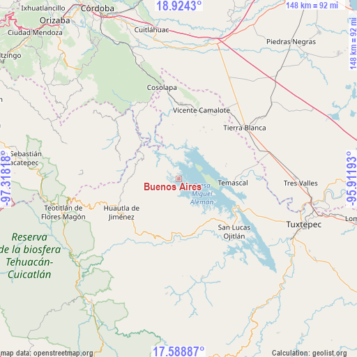
Buenos Aires GPS coordinates[2]
18° 15' 28.332" North, 96° 36' 54.18" West
| Map corner | latitude | longitude |
|---|---|---|
| Upper-left | 18.9243°, | -97.31818° |
| Center: | 18.25787°, | -96.61505° |
| Lower-right: | 17.58887°, | -95.91193° |
| Map W x H: | 148.5×148.5 km | = 92.3×92.3mi |
| max Lat: | 32.7° ⇑75.4% North |
| Buenos Aires: | 18.25787° |
| min Lat: | ⇓24.6% South 14.53588° |
| min Long | Buenos Aires | max Long |
| -117.105° | -96.61505° | -86.73105° |
| W 79.1%⇐ | ⇒20.9% E |
Elevation
Elevation of Buenos Aires is 84 m = 276 ft, and this is 1169.7 m = 3838 ft below average elevation for this country.
| Max E: |
3497 m = 11473 ft | 80.9% |
| Avg. | 1253.7 m = 4113 ft | |
| Buenos Aires | 84 m = 276 ft | |
Min E: |
-1 m = -3 ft | 19.1% |
See also: Mexico elevation on elevation.city.
Geographical zone
Buenos Aires is located in North Torrid zone (between Equator and Tropic of Cancer). Distance of this Northern Tropic circle is 575.8 km =357.8 mi to North.| Distance of | km | miles | from Buenos Aires |
|---|---|---|---|
| North Pole | 7977 | 4956.7 | to North |
| Arctic Circle | 5371.1 | 3337.4 | to North |
| Tropic Cancer | 575.8 | 357.8 | to North |
| Equator | 2030.1 | 1261.4 | to South |


Nearby cities:
15 places around Buenos Aires: (largest is in red/bold)
• Aguacatitla
14.5 km =9 mi,  239°
239°
• Arroyo Murciélago
14.3 km =8.9 mi,  150°
150°
• Barranca Seca
14.5 km =9 mi,  294°
294°
• Barranca Seca
15.4 km =9.6 mi,  256°
256°
• Cerro Clarín
6.6 km =4.1 mi, 286°
• Cerro Palmera
14.6 km =9.1 mi,  217°
217°
• Cerro Quemado
12.3 km =7.6 mi,  159°
159°
• El Progreso
16.3 km =10.1 mi, 153°
• Isla Soyaltepec
15.3 km =9.5 mi,  114°
114°
• Raya Caracol
16.1 km =10 mi,  328°
328°
• Río Lodo
8.3 km =5.2 mi,  301°
301°
• Río Sapo
11.1 km =6.9 mi,  278°
278°
• San Felipe Tílpam
8.2 km =5.1 mi, 158°
• San José Independencia
3.9 km =2.4 mi, 237°
• San José Tenango
16.1 km =10 mi, 222°
Sources, notices
• [Note1] Compared only with cities in Mexico existing in our database
• [Src1] Map data: © OpenStreetMap contributors (CC-BY-SA)
• [Src2] Other city data from geonames.org with taken over terms of usage.
• [Src3] Geographical zone / Annual Mean Temperature by Robert A. Rohde @ Wikipedia
