Macín Chico geodata
Macín Chico (Oaxaca) is a populated place; located in Mexico in America/Mexico_City (GMT-6) time zone. With population of 1,195 people, there are 7266 cities with bigger population in this country. Compared to other cities in Mexico, 77.9% of cities are located further ↑North; 81% of cities are located further ←West and 81.5% of cities have higher elevation than Macín Chico. Note1


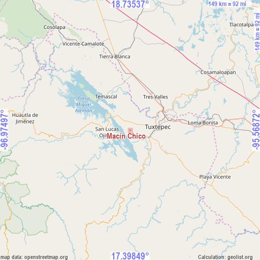
Macín Chico GPS coordinates[2]
18° 4' 5.52" North, 96° 16' 18.624" West
| Map corner | latitude | longitude |
|---|---|---|
| Upper-left | 18.73537°, | -96.97497° |
| Center: | 18.0682°, | -96.27184° |
| Lower-right: | 17.39849°, | -95.56872° |
| Map W x H: | 148.6×148.6 km | = 92.3×92.3mi |
| max Lat: | 32.7° ⇑77.9% North |
| Macín Chico: | 18.0682° |
| min Lat: | ⇓22.1% South 14.53588° |
| min Long | Macín Chico | max Long |
| -117.105° | -96.27184° | -86.73105° |
| W 81%⇐ | ⇒19% E |
Elevation
Elevation of Macín Chico is 76 m = 249 ft, and this is 1177.7 m = 3864 ft below average elevation for this country.
| Max E: |
3497 m = 11473 ft | 81.5% |
| Avg. | 1253.7 m = 4113 ft | |
| Macín Chico | 76 m = 249 ft | |
Min E: |
-1 m = -3 ft | 18.5% |
See also: Mexico elevation on elevation.city.
Geographical zone
Macín Chico is located in North Torrid zone (between Equator and Tropic of Cancer). Distance of this Northern Tropic circle is 596.9 km =370.9 mi to North.| Distance of | km | miles | from Macín Chico |
|---|---|---|---|
| North Pole | 7998.1 | 4969.8 | to North |
| Arctic Circle | 5392.2 | 3350.6 | to North |
| Tropic Cancer | 596.9 | 370.9 | to North |
| Equator | 2009 | 1248.3 | to South |


Nearby cities:
15 places around Macín Chico: (largest is in red/bold)
• Arroyo Camalote
14.5 km =9 mi,  279°
279°
• Buenos Aires el Apompo
8.6 km =5.3 mi,  346°
346°
• Camelia Roja
8.1 km =5 mi,  123°
123°
• Cerro Tepezcuintle
11.4 km =7.1 mi,  319°
319°
• El Camarón
8.6 km =5.3 mi,  57°
57°
• El Porvenir
11.3 km =7 mi,  30°
30°
• Fortino J. Pinacho
13.5 km =8.4 mi,  129°
129°
• Mazín Grande
6.7 km =4.2 mi, 323°
• Paso Canoa
7.1 km =4.4 mi,  149°
149°
• San Isidro
12.6 km =7.8 mi,  43°
43°
• San José Lagunas
12.9 km =8 mi,  293°
293°
• San Lucas Ojitlán
13.4 km =8.3 mi,  264°
264°
• Santa Ursula
7.8 km =4.8 mi, 150°
• Sebastopol
11.2 km =7 mi,  110°
110°
• Soledad Macín Chico
5.6 km =3.5 mi,  100°
100°
Sources, notices
• [Note1] Compared only with cities in Mexico existing in our database
• [Src1] Map data: © OpenStreetMap contributors (CC-BY-SA)
• [Src2] Other city data from geonames.org with taken over terms of usage.
• [Src3] Geographical zone / Annual Mean Temperature by Robert A. Rohde @ Wikipedia
