Puxcatán geodata
Puxcatán (Tabasco) is a populated place; located in Mexico in America/Mexico_City (GMT-6) time zone. With population of 1,288 people, there are 6735 cities with bigger population in this country. Compared to other cities in Mexico, 83.6% of cities are located further ↑North; 90.6% of cities are located further ←West and 83.3% of cities have higher elevation than Puxcatán. Note1


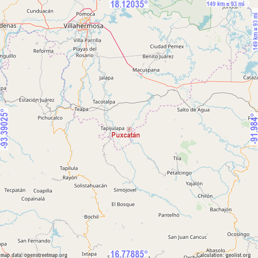
Puxcatán GPS coordinates[2]
17° 27' 2.988" North, 92° 41' 13.632" West
| Map corner | latitude | longitude |
|---|---|---|
| Upper-left | 18.12035°, | -93.39025° |
| Center: | 17.45083°, | -92.68712° |
| Lower-right: | 16.77885°, | -91.984° |
| Map W x H: | 149.2×149.2 km | = 92.7×92.7mi |
| max Lat: | 32.7° ⇑83.6% North |
| Puxcatán: | 17.45083° |
| min Lat: | ⇓16.4% South 14.53588° |
| min Long | Puxcatán | max Long |
| -117.105° | -92.68712° | -86.73105° |
| W 90.6%⇐ | ⇒9.4% E |
Elevation
Elevation of Puxcatán is 58 m = 190 ft, and this is 1195.7 m = 3923 ft below average elevation for this country.
| Max E: |
3497 m = 11473 ft | 83.3% |
| Avg. | 1253.7 m = 4113 ft | |
| Puxcatán | 58 m = 190 ft | |
Min E: |
-1 m = -3 ft | 16.7% |
See also: Mexico elevation on elevation.city.
Geographical zone
Puxcatán is located in North Torrid zone (between Equator and Tropic of Cancer). Distance of this Northern Tropic circle is 665.6 km =413.6 mi to North.| Distance of | km | miles | from Puxcatán |
|---|---|---|---|
| North Pole | 8066.7 | 5012.4 | to North |
| Arctic Circle | 5460.8 | 3393.2 | to North |
| Tropic Cancer | 665.6 | 413.6 | to North |
| Equator | 1940.4 | 1205.7 | to South |


Nearby cities:
15 places around Puxcatán: (largest is in red/bold)
• Agua Blanca
7.9 km =4.9 mi,  60°
60°
• Campamento el Mirador
11.2 km =7 mi,  175°
175°
• Cristóbal Colón
11.3 km =7 mi,  162°
162°
• Cuauhtémoc Barreal
4.6 km =2.9 mi,  235°
235°
• Cuitláhuac
11.4 km =7.1 mi,  204°
204°
• El Bebedero
7.2 km =4.5 mi,  145°
145°
• Guayal
13.2 km =8.2 mi,  44°
44°
• Jesús Carranza
5.5 km =3.4 mi,  141°
141°
• Libertad
5.4 km =3.4 mi,  213°
213°
• Moyos
11.3 km =7 mi, 154°
• Oxolotán
10.3 km =6.4 mi,  219°
219°
• Raya Zaragoza
5 km =3.1 mi, 177°
• Tapijulapa
9.8 km =6.1 mi,  277°
277°
• Unión Juárez
9.4 km =5.8 mi, 139°
• Xicoténcatl
7.7 km =4.8 mi,  346°
346°
Sources, notices
• [Note1] Compared only with cities in Mexico existing in our database
• [Src1] Map data: © OpenStreetMap contributors (CC-BY-SA)
• [Src2] Other city data from geonames.org with taken over terms of usage.
• [Src3] Geographical zone / Annual Mean Temperature by Robert A. Rohde @ Wikipedia
