Lomas Alegres 1ra. Sección geodata
Lomas Alegres 1ra. Sección (Tabasco) is a populated place; located in Mexico in America/Mexico_City (GMT-6) time zone. With population of 790 people, there are 11052 cities with bigger population in this country. Compared to other cities in Mexico, 82.3% of cities are located further ↑North; 90.7% of cities are located further ←West and 88% of cities have higher elevation than Lomas Alegres 1ra. Sección. Note1
Current local time in Lomas Alegres 1ra. Sección:
05:34 AM, WednesdayDifference from your time zone: hours


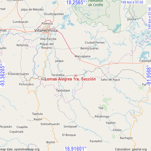
Lomas Alegres 1ra. Sección GPS coordinates[2]
17° 35' 15" North, 92° 39' 34.992" West
| Map corner | latitude | longitude |
|---|---|---|
| Upper-left | 18.2565°, | -93.36285° |
| Center: | 17.5875°, | -92.65972° |
| Lower-right: | 16.91601°, | -91.9566° |
| Map W x H: | 149×149.1 km | = 92.6×92.6mi |
| max Lat: | 32.7° ⇑82.3% North |
| Lomas Alegres 1ra. Sección: | 17.5875° |
| min Lat: | ⇓17.7% South 14.53588° |
| min Long | Lomas Alegres 1 | max Long |
| -117.105° | -92.65972° | -86.73105° |
| W 90.7%⇐ | ⇒9.3% E |
Elevation
Elevation of Lomas Alegres 1ra. Sección is 30 m = 98 ft, and this is 1223.7 m = 4015 ft below average elevation for this country.
| Max E: |
3497 m = 11473 ft | 88% |
| Avg. | 1253.7 m = 4113 ft | |
| Lomas Alegres 1ra. Sección | 30 m = 98 ft | |
Min E: |
-1 m = -3 ft | 12% |
See also: Mexico elevation on elevation.city.
Geographical zone
Lomas Alegres 1ra. Sección is located in North Torrid zone (between Equator and Tropic of Cancer). Distance of this Northern Tropic circle is 650.4 km =404.1 mi to North.| Distance of | km | miles | from Lomas Alegres 1ra. Sección |
|---|---|---|---|
| North Pole | 8051.5 | 5003 | to North |
| Arctic Circle | 5445.6 | 3383.7 | to North |
| Tropic Cancer | 650.4 | 404.1 | to North |
| Equator | 1955.5 | 1215.1 | to South |


Nearby cities:
15 places around Lomas Alegres 1ra. Sección: (largest is in red/bold)
• Agua Blanca
12 km =7.5 mi,  160°
160°
• Buena Vista (Puxcatán)
16.5 km =10.3 mi,  14°
14°
• Calicanto 2da. Sección
11.8 km =7.3 mi,  333°
333°
• Cerro Misopa
15.3 km =9.5 mi,  103°
103°
• Francisco Villa
13.5 km =8.4 mi,  54°
54°
• Guayal
8.6 km =5.3 mi,  132°
132°
• Nicolás Bravo
14.9 km =9.3 mi,  17°
17°
• Paso Chinal
18.6 km =11.6 mi,  123°
123°
• Pochitocal 1ra. Sección (La Palma)
10.1 km =6.3 mi,  297°
297°
• Profesor Caparroso 1ra. Sección
17.5 km =10.9 mi,  76°
76°
• Puxcatán
15.5 km =9.6 mi,  190°
190°
• San Miguel Adentro 1ra. Sección
16 km =9.9 mi,  339°
339°
• San Ramón
16.7 km =10.4 mi,  265°
265°
• Tacotalpa
17.6 km =10.9 mi, 273°
• Xicoténcatl
9.1 km =5.7 mi,  211°
211°
Sources, notices
• [Note1] Compared only with cities in Mexico existing in our database
• [Src1] Map data: © OpenStreetMap contributors (CC-BY-SA)
• [Src2] Other city data from geonames.org with taken over terms of usage.
• [Src3] Geographical zone / Annual Mean Temperature by Robert A. Rohde @ Wikipedia
