Tezontla geodata
Tezontla (San Luis Potosí) is a populated place; located in Mexico in America/Mexico_City (GMT-6) time zone. With population of 642 people, there are 13481 cities with bigger population in this country. Compared to other cities in Mexico, 79.5% of cities are located further ↓South; 55.2% of cities are located further ←West and 77.5% of cities have higher elevation than Tezontla. Note1


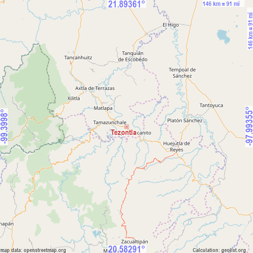
Tezontla GPS coordinates[2]
21° 14' 22.992" North, 98° 41' 48.012" West
| Map corner | latitude | longitude |
|---|---|---|
| Upper-left | 21.89361°, | -99.3998° |
| Center: | 21.23972°, | -98.69667° |
| Lower-right: | 20.58291°, | -97.99355° |
| Map W x H: | 145.7×145.7 km | = 90.5×90.5mi |
| max Lat: | 32.7° ⇑20.5% North |
| Tezontla: | 21.23972° |
| min Lat: | ⇓79.5% South 14.53588° |
| min Long | Tezontla | max Long |
| -117.105° | -98.69667° | -86.73105° |
| W 55.2%⇐ | ⇒44.8% E |
Elevation
Elevation of Tezontla is 142 m = 466 ft, and this is 1111.7 m = 3647 ft below average elevation for this country.
| Max E: |
3497 m = 11473 ft | 77.5% |
| Avg. | 1253.7 m = 4113 ft | |
| Tezontla | 142 m = 466 ft | |
Min E: |
-1 m = -3 ft | 22.5% |
See also: Mexico elevation on elevation.city.
Geographical zone
Tezontla is located in North Torrid zone (between Equator and Tropic of Cancer). Distance of this Northern Tropic circle is 244.3 km =151.8 mi to North.| Distance of | km | miles | from Tezontla |
|---|---|---|---|
| North Pole | 7645.4 | 4750.6 | to North |
| Arctic Circle | 5039.5 | 3131.4 | to North |
| Tropic Cancer | 244.3 | 151.8 | to North |
| Equator | 2361.6 | 1467.4 | to South |


Nearby cities:
15 places around Tezontla: (largest is in red/bold)
• Chapulhuacanito
4.4 km =2.7 mi,  141°
141°
• Coaxocotitla
8.6 km =5.3 mi,  247°
247°
• Cojolapa
2.1 km =1.3 mi,  204°
204°
• El Palmito
1.6 km =1 mi,  311°
311°
• El Piñal
5.6 km =3.5 mi,  283°
283°
• El Tepetate
7.9 km =4.9 mi,  318°
318°
• Huitzitzilingo
8.5 km =5.3 mi,  150°
150°
• Ixtlapalaco
8.1 km =5 mi,  293°
293°
• La Cichilla
5.9 km =3.7 mi,  330°
330°
• Pahuayo
7.4 km =4.6 mi,  187°
187°
• Rancho Nuevo
5.4 km =3.4 mi,  215°
215°
• Santa Lucía
8.6 km =5.3 mi, 186°
• Santa María Picula
6.5 km =4 mi,  229°
229°
• Temamatla
6.8 km =4.2 mi,  265°
265°
• Tianguispicula
5.6 km =3.5 mi, 190°
Sources, notices
• [Note1] Compared only with cities in Mexico existing in our database
• [Src1] Map data: © OpenStreetMap contributors (CC-BY-SA)
• [Src2] Other city data from geonames.org with taken over terms of usage.
• [Src3] Geographical zone / Annual Mean Temperature by Robert A. Rohde @ Wikipedia
