El Palmito geodata
El Palmito (San Luis Potosí) is a populated place; located in Mexico in America/Mexico_City (GMT-6) time zone. With population of 902 people, there are 9667 cities with bigger population in this country. Compared to other cities in Mexico, 79.6% of cities are located further ↓South; 55% of cities are located further ←West and 76.9% of cities have higher elevation than El Palmito. Note1


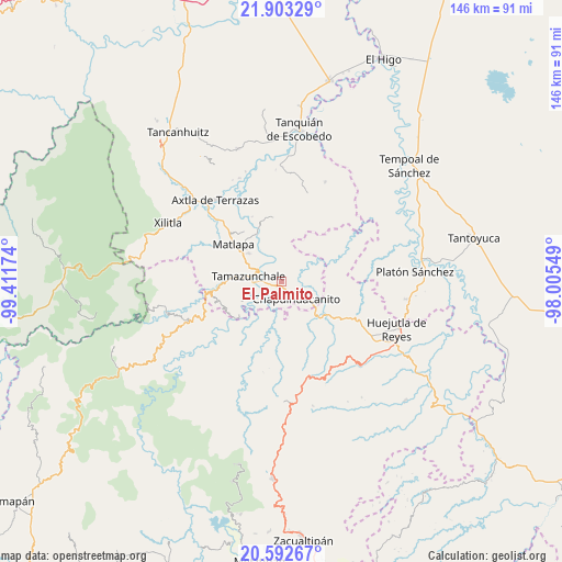
El Palmito GPS coordinates[2]
21° 14' 57.984" North, 98° 42' 30.996" West
| Map corner | latitude | longitude |
|---|---|---|
| Upper-left | 21.90329°, | -99.41174° |
| Center: | 21.24944°, | -98.70861° |
| Lower-right: | 20.59267°, | -98.00549° |
| Map W x H: | 145.7×145.7 km | = 90.5×90.5mi |
| max Lat: | 32.7° ⇑20.4% North |
| El Palmito: | 21.24944° |
| min Lat: | ⇓79.6% South 14.53588° |
| min Long | El Palmito | max Long |
| -117.105° | -98.70861° | -86.73105° |
| W 55%⇐ | ⇒45% E |
Elevation
Elevation of El Palmito is 155 m = 509 ft, and this is 1098.7 m = 3605 ft below average elevation for this country.
| Max E: |
3497 m = 11473 ft | 76.9% |
| Avg. | 1253.7 m = 4113 ft | |
| El Palmito | 155 m = 509 ft | |
Min E: |
-1 m = -3 ft | 23.1% |
See also: Mexico elevation on elevation.city.
Geographical zone
El Palmito is located in North Torrid zone (between Equator and Tropic of Cancer). Distance of this Northern Tropic circle is 243.2 km =151.1 mi to North.| Distance of | km | miles | from El Palmito |
|---|---|---|---|
| North Pole | 7644.3 | 4749.9 | to North |
| Arctic Circle | 5038.5 | 3130.8 | to North |
| Tropic Cancer | 243.2 | 151.1 | to North |
| Equator | 2362.7 | 1468.1 | to South |


Nearby cities:
15 places around El Palmito: (largest is in red/bold)
• Chapulhuacanito
6 km =3.7 mi,  138°
138°
• Coaxocotitla
8 km =5 mi,  236°
236°
• Cojolapa
3 km =1.9 mi,  173°
173°
• Cuixcuatitla
8.2 km =5.1 mi,  311°
311°
• El Piñal
4.2 km =2.6 mi,  272°
272°
• El Tepetate
6.3 km =3.9 mi,  320°
320°
• Ixtlapalaco
6.5 km =4 mi,  288°
288°
• La Cichilla
4.4 km =2.7 mi,  338°
338°
• Pahuayo
8.4 km =5.2 mi,  178°
178°
• Rancho Nuevo
5.8 km =3.6 mi,  198°
198°
• Santa María Picula
6.4 km =4 mi,  215°
215°
• Tamazunchale
8.4 km =5.2 mi,  277°
277°
• Temamatla
5.8 km =3.6 mi,  253°
253°
• Tezontla
1.6 km =1 mi,  131°
131°
• Tianguispicula
6.6 km =4.1 mi, 177°
Sources, notices
• [Note1] Compared only with cities in Mexico existing in our database
• [Src1] Map data: © OpenStreetMap contributors (CC-BY-SA)
• [Src2] Other city data from geonames.org with taken over terms of usage.
• [Src3] Geographical zone / Annual Mean Temperature by Robert A. Rohde @ Wikipedia
