Acanoa geodata
Acanoa (Veracruz) is a populated place; located in Mexico in America/Mexico_City (GMT-6) time zone. With population of 710 people, there are 12262 cities with bigger population in this country. Compared to other cities in Mexico, 73.3% of cities are located further ↓South; 60.3% of cities are located further ←West and 67.4% of cities have higher elevation than Acanoa. Note1


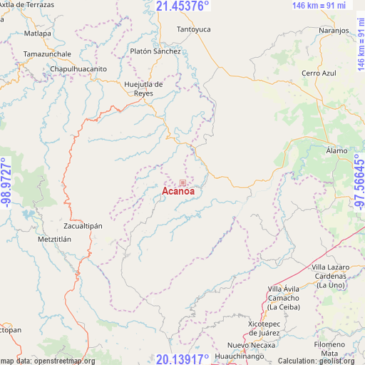
Acanoa GPS coordinates[2]
20° 47' 52.44" North, 98° 16' 10.452" West
| Map corner | latitude | longitude |
|---|---|---|
| Upper-left | 21.45376°, | -98.9727° |
| Center: | 20.7979°, | -98.26957° |
| Lower-right: | 20.13917°, | -97.56645° |
| Map W x H: | 146.2×146.2 km | = 90.8×90.8mi |
| max Lat: | 32.7° ⇑26.7% North |
| Acanoa: | 20.7979° |
| min Lat: | ⇓73.3% South 14.53588° |
| min Long | Acanoa | max Long |
| -117.105° | -98.26957° | -86.73105° |
| W 60.3%⇐ | ⇒39.7% E |
Elevation
Elevation of Acanoa is 558 m = 1831 ft, and this is 695.7 m = 2282 ft below average elevation for this country.
| Max E: |
3497 m = 11473 ft | 67.4% |
| Avg. | 1253.7 m = 4113 ft | |
| Acanoa | 558 m = 1831 ft | |
Min E: |
-1 m = -3 ft | 32.6% |
See also: Mexico elevation on elevation.city.
Geographical zone
Acanoa is located in North Torrid zone (between Equator and Tropic of Cancer). Distance of this Northern Tropic circle is 293.4 km =182.3 mi to North.| Distance of | km | miles | from Acanoa |
|---|---|---|---|
| North Pole | 7694.6 | 4781.2 | to North |
| Arctic Circle | 5088.7 | 3162 | to North |
| Tropic Cancer | 293.4 | 182.3 | to North |
| Equator | 2312.5 | 1436.9 | to South |


Nearby cities:
15 places around Acanoa: (largest is in red/bold)
• Atlalco
2.8 km =1.7 mi,  323°
323°
• El Mamey
4.4 km =2.7 mi,  225°
225°
• La Candelaria
6.9 km =4.3 mi,  239°
239°
• Limontitla
7.7 km =4.8 mi,  152°
152°
• Nanayatla
3 km =1.9 mi,  14°
14°
• Otlamalacatl
6.2 km =3.9 mi,  50°
50°
• Otlatzintla
3 km =1.9 mi,  133°
133°
• Pocantla
6.8 km =4.2 mi, 318°
• Primo Verdad
6.2 km =3.9 mi,  64°
64°
• Tetzacual
2.7 km =1.7 mi,  178°
178°
• Tlaltecatla
7.6 km =4.7 mi,  348°
348°
• Xochiatipan de Castillo
4.5 km =2.8 mi,  338°
338°
• Xococapa
8.6 km =5.3 mi,  278°
278°
• Xocotitla
3.3 km =2.1 mi,  300°
300°
• Zontecomatlán de López y Fuentes
8.6 km =5.3 mi, 242°
Sources, notices
• [Note1] Compared only with cities in Mexico existing in our database
• [Src1] Map data: © OpenStreetMap contributors (CC-BY-SA)
• [Src2] Other city data from geonames.org with taken over terms of usage.
• [Src3] Geographical zone / Annual Mean Temperature by Robert A. Rohde @ Wikipedia
