Huazalingo geodata
Huazalingo (Hidalgo) is a populated place; located in Mexico in America/Mexico_City (GMT-6) time zone. With population of 842 people, there are 10390 cities with bigger population in this country. Compared to other cities in Mexico, 76.2% of cities are located further ↓South; 57.1% of cities are located further ←West and 61.7% of cities have higher elevation than Huazalingo. Note1


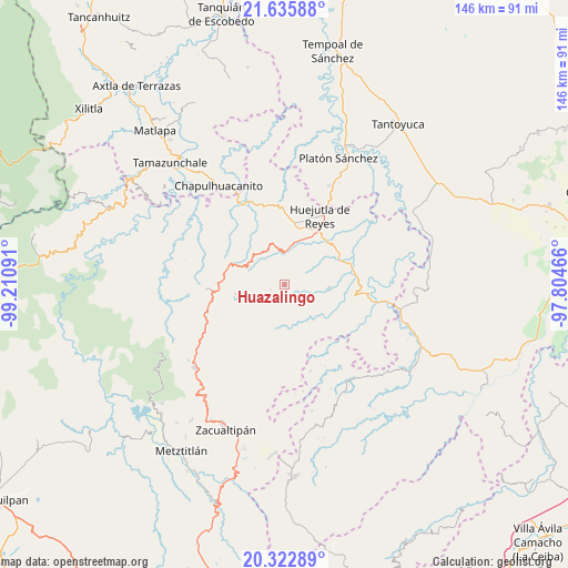
Huazalingo GPS coordinates[2]
20° 58' 50.988" North, 98° 30' 28.008" West
| Map corner | latitude | longitude |
|---|---|---|
| Upper-left | 21.63588°, | -99.21091° |
| Center: | 20.98083°, | -98.50778° |
| Lower-right: | 20.32289°, | -97.80466° |
| Map W x H: | 146×146 km | = 90.7×90.7mi |
| max Lat: | 32.7° ⇑23.8% North |
| Huazalingo: | 20.98083° |
| min Lat: | ⇓76.2% South 14.53588° |
| min Long | Huazalingo | max Long |
| -117.105° | -98.50778° | -86.73105° |
| W 57.1%⇐ | ⇒42.9% E |
Elevation
Elevation of Huazalingo is 897 m = 2943 ft, and this is 356.7 m = 1170 ft below average elevation for this country.
| Max E: |
3497 m = 11473 ft | 61.7% |
| Avg. | 1253.7 m = 4113 ft | |
| Huazalingo | 897 m = 2943 ft | |
Min E: |
-1 m = -3 ft | 38.3% |
See also: Mexico elevation on elevation.city.
Geographical zone
Huazalingo is located in North Torrid zone (between Equator and Tropic of Cancer). Distance of this Northern Tropic circle is 273.1 km =169.7 mi to North.| Distance of | km | miles | from Huazalingo |
|---|---|---|---|
| North Pole | 7674.2 | 4768.5 | to North |
| Arctic Circle | 5068.3 | 3149.3 | to North |
| Tropic Cancer | 273.1 | 169.7 | to North |
| Equator | 2332.8 | 1449.5 | to South |


Nearby cities:
15 places around Huazalingo: (largest is in red/bold)
• Apantlazol
7.9 km =4.9 mi,  276°
276°
• Chatipán
4.8 km =3 mi,  335°
335°
• Coamitla
8.9 km =5.5 mi,  172°
172°
• Coyula
6.6 km =4.1 mi,  157°
157°
• Machetla
8.9 km =5.5 mi,  8°
8°
• Olotla
6.3 km =3.9 mi,  268°
268°
• Pilchatipa
7.1 km =4.4 mi,  33°
33°
• Pilcuatla
5.6 km =3.5 mi,  232°
232°
• San Andrés (San Andrés Chichayotla)
8.3 km =5.2 mi,  223°
223°
• San Francisco
4.7 km =2.9 mi, 27°
• San Isidro
8.9 km =5.5 mi,  62°
62°
• Santo Tomás
5.8 km =3.6 mi,  82°
82°
• Tehuetlán
8.1 km =5 mi,  359°
359°
• Tlamamala
3.7 km =2.3 mi,  249°
249°
• Toctitlán
8.4 km =5.2 mi,  293°
293°
Sources, notices
• [Note1] Compared only with cities in Mexico existing in our database
• [Src1] Map data: © OpenStreetMap contributors (CC-BY-SA)
• [Src2] Other city data from geonames.org with taken over terms of usage.
• [Src3] Geographical zone / Annual Mean Temperature by Robert A. Rohde @ Wikipedia
