Coyula geodata
Coyula (Hidalgo) is a populated place; located in Mexico in America/Mexico_City (GMT-6) time zone. With population of 827 people, there are 10571 cities with bigger population in this country. Compared to other cities in Mexico, 75.3% of cities are located further ↓South; 57.5% of cities are located further ←West and 63% of cities have higher elevation than Coyula. Note1


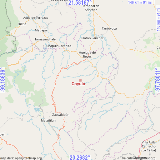
Coyula GPS coordinates[2]
20° 55' 34.932" North, 98° 28' 59.628" West
| Map corner | latitude | longitude |
|---|---|---|
| Upper-left | 21.58167°, | -99.18636° |
| Center: | 20.92637°, | -98.48323° |
| Lower-right: | 20.2682°, | -97.78011° |
| Map W x H: | 146×146 km | = 90.7×90.7mi |
| max Lat: | 32.7° ⇑24.7% North |
| Coyula: | 20.92637° |
| min Lat: | ⇓75.3% South 14.53588° |
| min Long | Coyula | max Long |
| -117.105° | -98.48323° | -86.73105° |
| W 57.5%⇐ | ⇒42.5% E |
Elevation
Elevation of Coyula is 814 m = 2671 ft, and this is 439.7 m = 1443 ft below average elevation for this country.
| Max E: |
3497 m = 11473 ft | 63% |
| Avg. | 1253.7 m = 4113 ft | |
| Coyula | 814 m = 2671 ft | |
Min E: |
-1 m = -3 ft | 37% |
See also: Mexico elevation on elevation.city.
Geographical zone
Coyula is located in North Torrid zone (between Equator and Tropic of Cancer). Distance of this Northern Tropic circle is 279.1 km =173.4 mi to North.| Distance of | km | miles | from Coyula |
|---|---|---|---|
| North Pole | 7680.3 | 4772.3 | to North |
| Arctic Circle | 5074.4 | 3153.1 | to North |
| Tropic Cancer | 279.1 | 173.4 | to North |
| Equator | 2326.8 | 1445.8 | to South |


Nearby cities:
15 places around Coyula: (largest is in red/bold)
• Aguacatitla
9.2 km =5.7 mi,  141°
141°
• Atempa
4.8 km =3 mi,  188°
188°
• Coamitla
3.1 km =1.9 mi,  206°
206°
• Huazalingo
6.6 km =4.1 mi,  337°
337°
• Mecatlán
8.4 km =5.2 mi,  82°
82°
• Papatlatla
4.3 km =2.7 mi,  130°
130°
• Pepeyocatitla
9 km =5.6 mi,  98°
98°
• Pilcuatla
7.5 km =4.7 mi,  290°
290°
• San Andrés (San Andrés Chichayotla)
8.3 km =5.2 mi,  270°
270°
• Santa Lucía (Mesa de Santa Lucía)
5.1 km =3.2 mi, 78°
• Santo Tomás
7.5 km =4.7 mi,  25°
25°
• Tlalchiyahualica
10 km =6.2 mi,  60°
60°
• Tlamamala
7.7 km =4.8 mi,  308°
308°
• Xoxolpa
8.4 km =5.2 mi, 132°
• Zoquitipán
5.6 km =3.5 mi,  110°
110°
Sources, notices
• [Note1] Compared only with cities in Mexico existing in our database
• [Src1] Map data: © OpenStreetMap contributors (CC-BY-SA)
• [Src2] Other city data from geonames.org with taken over terms of usage.
• [Src3] Geographical zone / Annual Mean Temperature by Robert A. Rohde @ Wikipedia
