Xoxoteco geodata
Xoxoteco (Hidalgo) is a populated place; located in Mexico in America/Mexico_City (GMT-6) time zone. With population of 597 people, there are 14400 cities with bigger population in this country. Compared to other cities in Mexico, 68.1% of cities are located further ↓South; 55.8% of cities are located further ←West and 50.8% of cities have higher elevation than Xoxoteco. Note1


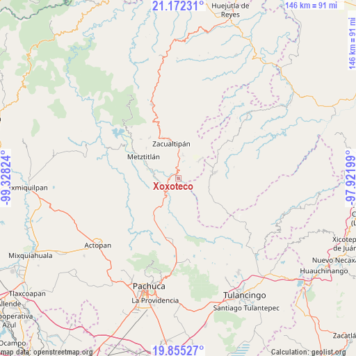
Xoxoteco GPS coordinates[2]
20° 30' 54.756" North, 98° 37' 30.396" West
| Map corner | latitude | longitude |
|---|---|---|
| Upper-left | 21.17231°, | -99.32824° |
| Center: | 20.51521°, | -98.62511° |
| Lower-right: | 19.85527°, | -97.92199° |
| Map W x H: | 146.4×146.4 km | = 91×91mi |
| max Lat: | 32.7° ⇑31.9% North |
| Xoxoteco: | 20.51521° |
| min Lat: | ⇓68.1% South 14.53588° |
| min Long | Xoxoteco | max Long |
| -117.105° | -98.62511° | -86.73105° |
| W 55.8%⇐ | ⇒44.2% E |
Elevation
Elevation of Xoxoteco is 1389 m = 4557 ft, and this is 135.3 m = 444 ft above average elevation for this country.
| Max E: |
3497 m = 11473 ft | 50.8% |
| Xoxoteco | 1389 m 4557 ft | |
| Avg. | 1253.7 m = 4113 ft | |
Min E: |
-1 m = -3 ft | 49.2% |
See also: Mexico elevation on elevation.city.
Geographical zone
Xoxoteco is located in North Torrid zone (between Equator and Tropic of Cancer). Distance of this Northern Tropic circle is 324.8 km =201.8 mi to North.| Distance of | km | miles | from Xoxoteco |
|---|---|---|---|
| North Pole | 7726 | 4800.7 | to North |
| Arctic Circle | 5120.1 | 3181.5 | to North |
| Tropic Cancer | 324.8 | 201.8 | to North |
| Equator | 2281.1 | 1417.4 | to South |


Nearby cities:
15 places around Xoxoteco: (largest is in red/bold)
• Atecoxco
3.9 km =2.4 mi,  101°
101°
• Atopixco
9.8 km =6.1 mi,  10°
10°
• Carpinteros
11.9 km =7.4 mi,  48°
48°
• Cerro Colorado
15.4 km =9.6 mi,  218°
218°
• Huayacocotla
15.2 km =9.4 mi,  80°
80°
• La Mojonera
12.3 km =7.6 mi,  2°
2°
• La Selva
13.8 km =8.6 mi,  65°
65°
• Mezquititlán
2.4 km =1.5 mi,  327°
327°
• Palo Bendito
14.5 km =9 mi,  116°
116°
• Santa Mónica Autempa
10.5 km =6.5 mi,  231°
231°
• Teximalpa
16.1 km =10 mi,  135°
135°
• Tizapán
15.4 km =9.6 mi, 10°
• Tlahuelompa (San Francisco Tlahuelompa)
15.9 km =9.9 mi,  19°
19°
• Tuzanapa
8.3 km =5.2 mi,  30°
30°
• Zacualtipán
15.3 km =9.5 mi,  347°
347°
Sources, notices
• [Note1] Compared only with cities in Mexico existing in our database
• [Src1] Map data: © OpenStreetMap contributors (CC-BY-SA)
• [Src2] Other city data from geonames.org with taken over terms of usage.
• [Src3] Geographical zone / Annual Mean Temperature by Robert A. Rohde @ Wikipedia
