Hueyapita geodata
Hueyapita (Hidalgo) is a populated place; located in Mexico in America/Mexico_City (GMT-6) time zone. With population of 895 people, there are 9743 cities with bigger population in this country. Compared to other cities in Mexico, 58.6% of cities are located further ↓South; 60.6% of cities are located further ←West and 91.3% of cities have lower elevation than Hueyapita. Note1


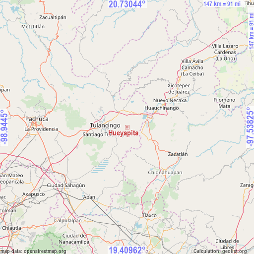
Hueyapita GPS coordinates[2]
20° 4' 17.112" North, 98° 14' 28.932" West
| Map corner | latitude | longitude |
|---|---|---|
| Upper-left | 20.73044°, | -98.9445° |
| Center: | 20.07142°, | -98.24137° |
| Lower-right: | 19.40962°, | -97.53825° |
| Map W x H: | 146.9×146.9 km | = 91.3×91.3mi |
| max Lat: | 32.7° ⇑41.4% North |
| Hueyapita: | 20.07142° |
| min Lat: | ⇓58.6% South 14.53588° |
| min Long | Hueyapita | max Long |
| -117.105° | -98.24137° | -86.73105° |
| W 60.6%⇐ | ⇒39.4% E |
Elevation
Elevation of Hueyapita is 2455 m = 8054 ft, and this is 1201.3 m = 3941 ft above average elevation for this country.
| Max E: |
3497 m = 11473 ft | 8.7% |
| Hueyapita | 2455 m 8054 ft | |
| Avg. | 1253.7 m = 4113 ft | |
Min E: |
-1 m = -3 ft | 91.3% |
See also: Mexico elevation on elevation.city.
Geographical zone
Hueyapita is located in North Torrid zone (between Equator and Tropic of Cancer). Distance of this Northern Tropic circle is 374.2 km =232.5 mi to North.| Distance of | km | miles | from Hueyapita |
|---|---|---|---|
| North Pole | 7775.3 | 4831.3 | to North |
| Arctic Circle | 5169.4 | 3212.1 | to North |
| Tropic Cancer | 374.2 | 232.5 | to North |
| Equator | 2231.7 | 1386.7 | to South |


Nearby cities:
15 places around Hueyapita: (largest is in red/bold)
• Ahuazotepec
8.7 km =5.4 mi,  109°
109°
• Buenos Aires
7.7 km =4.8 mi,  223°
223°
• Cerro Verde
5.7 km =3.5 mi,  251°
251°
• Coyametepec
6.8 km =4.2 mi,  43°
43°
• Cuautepec de Hinojosa
8.2 km =5.1 mi,  240°
240°
• El Capulín
7.8 km =4.8 mi,  207°
207°
• El Tepeyac
7.6 km =4.7 mi, 252°
• Guadalupe Victoria
4.7 km =2.9 mi, 217°
• La Mesa
2.6 km =1.6 mi, 38°
• Las Puentes
6.6 km =4.1 mi,  116°
116°
• Loma Bonita
7 km =4.3 mi,  256°
256°
• San Juan Hueyapan
6.3 km =3.9 mi, 222°
• Santa Elena Paliseca
8.2 km =5.1 mi,  180°
180°
• Santa María Nativitas
6.7 km =4.2 mi, 237°
• Tepaltzingo
8.5 km =5.3 mi,  330°
330°
Sources, notices
• [Note1] Compared only with cities in Mexico existing in our database
• [Src1] Map data: © OpenStreetMap contributors (CC-BY-SA)
• [Src2] Other city data from geonames.org with taken over terms of usage.
• [Src3] Geographical zone / Annual Mean Temperature by Robert A. Rohde @ Wikipedia
