Las Puentes geodata
Las Puentes (Hidalgo) is a populated place; located in Mexico in America/Mexico_City (GMT-6) time zone. With population of 817 people, there are 10690 cities with bigger population in this country. Compared to other cities in Mexico, 57.9% of cities are located further ↓South; 61.5% of cities are located further ←West and 88.7% of cities have lower elevation than Las Puentes. Note1


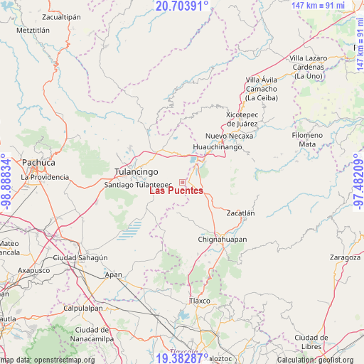
Las Puentes GPS coordinates[2]
20° 2' 41.208" North, 98° 11' 6.756" West
| Map corner | latitude | longitude |
|---|---|---|
| Upper-left | 20.70391°, | -98.88834° |
| Center: | 20.04478°, | -98.18521° |
| Lower-right: | 19.38287°, | -97.48209° |
| Map W x H: | 146.9×146.9 km | = 91.3×91.3mi |
| max Lat: | 32.7° ⇑42.1% North |
| Las Puentes: | 20.04478° |
| min Lat: | ⇓57.9% South 14.53588° |
| min Long | Las Puentes | max Long |
| -117.105° | -98.18521° | -86.73105° |
| W 61.5%⇐ | ⇒38.5% E |
Elevation
Elevation of Las Puentes is 2363 m = 7753 ft, and this is 1109.3 m = 3639 ft above average elevation for this country.
| Max E: |
3497 m = 11473 ft | 11.3% |
| Las Puentes | 2363 m 7753 ft | |
| Avg. | 1253.7 m = 4113 ft | |
Min E: |
-1 m = -3 ft | 88.7% |
See also: Mexico elevation on elevation.city.
Geographical zone
Las Puentes is located in North Torrid zone (between Equator and Tropic of Cancer). Distance of this Northern Tropic circle is 377.1 km =234.3 mi to North.| Distance of | km | miles | from Las Puentes |
|---|---|---|---|
| North Pole | 7778.3 | 4833.2 | to North |
| Arctic Circle | 5172.4 | 3214 | to North |
| Tropic Cancer | 377.1 | 234.3 | to North |
| Equator | 2228.8 | 1384.9 | to South |


Nearby cities:
15 places around Las Puentes: (largest is in red/bold)
• Ahuazotepec
2.3 km =1.4 mi,  88°
88°
• Atotonilco
7.4 km =4.6 mi,  132°
132°
• Beristain
7.8 km =4.8 mi,  44°
44°
• Coyametepec
7.9 km =4.9 mi,  351°
351°
• El Capulín
10.3 km =6.4 mi,  247°
247°
• Guadalupe Victoria
8.8 km =5.5 mi,  264°
264°
• Hueyapita
6.6 km =4.1 mi,  296°
296°
• La Estación de Ahuazotepec
3.6 km =2.2 mi,  80°
80°
• La Mesa
6.6 km =4.1 mi,  319°
319°
• Laguna Seca
6.3 km =3.9 mi, 94°
• Mesa de Capulines
10.2 km =6.3 mi, 42°
• Nanacamila
8.1 km =5 mi,  118°
118°
• San Juan Hueyapan
10.2 km =6.3 mi, 260°
• Santa Elena Paliseca
7.8 km =4.8 mi,  228°
228°
• Tepepa
10.1 km =6.3 mi,  8°
8°
Sources, notices
• [Note1] Compared only with cities in Mexico existing in our database
• [Src1] Map data: © OpenStreetMap contributors (CC-BY-SA)
• [Src2] Other city data from geonames.org with taken over terms of usage.
• [Src3] Geographical zone / Annual Mean Temperature by Robert A. Rohde @ Wikipedia
