El Pinar geodata
El Pinar (Chiapas) is a populated place; located in Mexico in America/Mexico_City (GMT-6) time zone. With population of 931 people, there are 9365 cities with bigger population in this country. Compared to other cities in Mexico, 92.2% of cities are located further ↑North; 91.1% of cities are located further ←West and 90.6% of cities have lower elevation than El Pinar. Note1


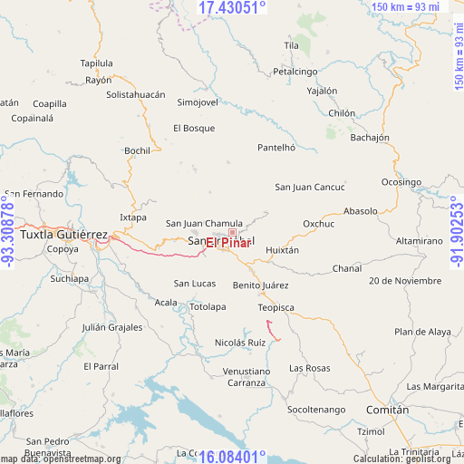
El Pinar GPS coordinates[2]
16° 45' 30.42" North, 92° 36' 20.34" West
| Map corner | latitude | longitude |
|---|---|---|
| Upper-left | 17.43051°, | -93.30878° |
| Center: | 16.75845°, | -92.60565° |
| Lower-right: | 16.08401°, | -91.90253° |
| Map W x H: | 149.7×149.7 km | = 93×93mi |
| max Lat: | 32.7° ⇑92.2% North |
| El Pinar: | 16.75845° |
| min Lat: | ⇓7.8% South 14.53588° |
| min Long | El Pinar | max Long |
| -117.105° | -92.60565° | -86.73105° |
| W 91.1%⇐ | ⇒8.9% E |
Elevation
Elevation of El Pinar is 2427 m = 7963 ft, and this is 1173.3 m = 3849 ft above average elevation for this country.
| Max E: |
3497 m = 11473 ft | 9.4% |
| El Pinar | 2427 m 7963 ft | |
| Avg. | 1253.7 m = 4113 ft | |
Min E: |
-1 m = -3 ft | 90.6% |
See also: Mexico elevation on elevation.city.
Geographical zone
El Pinar is located in North Torrid zone (between Equator and Tropic of Cancer). Distance of this Northern Tropic circle is 742.6 km =461.4 mi to North.| Distance of | km | miles | from El Pinar |
|---|---|---|---|
| North Pole | 8143.7 | 5060.3 | to North |
| Arctic Circle | 5537.8 | 3441 | to North |
| Tropic Cancer | 742.6 | 461.4 | to North |
| Equator | 1863.4 | 1157.9 | to South |


Nearby cities:
15 places around El Pinar: (largest is in red/bold)
• Agua de Pajarito
4.8 km =3 mi,  121°
121°
• Chilimjoveltic
4.3 km =2.7 mi,  40°
40°
• Cruztón
2.8 km =1.7 mi,  82°
82°
• El Crucero
6.3 km =3.9 mi, 41°
• Joltzemén
5.6 km =3.5 mi,  342°
342°
• Laguna Petej
7.5 km =4.7 mi,  297°
297°
• Las Ollas
6.2 km =3.9 mi,  65°
65°
• Milpoleta
6.1 km =3.8 mi,  284°
284°
• Molino los Arcos
1.5 km =0.9 mi,  195°
195°
• Muquén
5.4 km =3.4 mi,  354°
354°
• Romerillo
4.1 km =2.5 mi, 79°
• Saclamantón
4.6 km =2.9 mi,  316°
316°
• Sactzu
4.2 km =2.6 mi,  355°
355°
• San Antonio del Monte
5.1 km =3.2 mi,  272°
272°
• San Cristóbal de las Casas
4.8 km =3 mi,  231°
231°
Sources, notices
• [Note1] Compared only with cities in Mexico existing in our database
• [Src1] Map data: © OpenStreetMap contributors (CC-BY-SA)
• [Src2] Other city data from geonames.org with taken over terms of usage.
• [Src3] Geographical zone / Annual Mean Temperature by Robert A. Rohde @ Wikipedia
