San Cristóbal de las Casas geodata
San Cristóbal de las Casas (Chiapas) is a seat of a second-order administrative division; located in Mexico in America/Mexico_City (GMT-6) time zone. With population of 158,027 people, there are 99 cities with bigger population in this country. Compared to other cities in Mexico, 92.5% of cities are located further ↑North; 90.9% of cities are located further ←West and 79.4% of cities have lower elevation than San Cristóbal de las Casas. Note1
Current local time in San Cristóbal de las Casas:
06:46 AM, WednesdayDifference from your time zone: hours


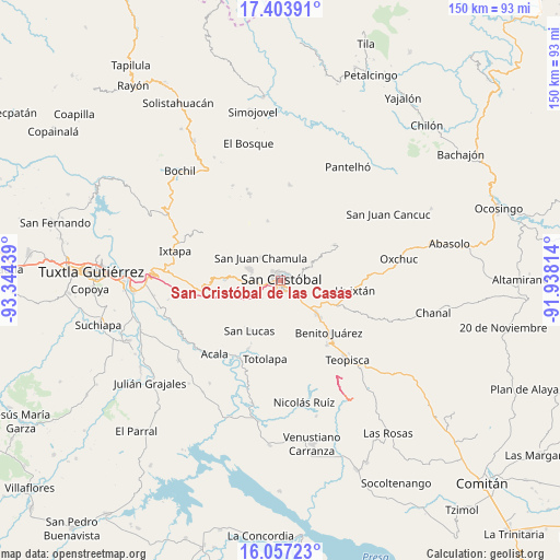
San Cristóbal de las Casas GPS coordinates[2]
16° 43' 54.336" North, 92° 38' 28.536" West
| Map corner | latitude | longitude |
|---|---|---|
| Upper-left | 17.40391°, | -93.34439° |
| Center: | 16.73176°, | -92.64126° |
| Lower-right: | 16.05723°, | -91.93814° |
| Map W x H: | 149.7×149.7 km | = 93×93mi |
| max Lat: | 32.7° ⇑92.5% North |
| San Cristóbal de las Casas: | 16.73176° |
| min Lat: | ⇓7.5% South 14.53588° |
| min Long | San Cristóbal | max Long |
| -117.105° | -92.64126° | -86.73105° |
| W 90.9%⇐ | ⇒9.1% E |
Elevation
Elevation of San Cristóbal de las Casas is 2125 m = 6972 ft, and this is 871.3 m = 2859 ft above average elevation for this country.
| Max E: |
3497 m = 11473 ft | 20.6% |
| San Cristóbal de las Casas | 2125 m 6972 ft | |
| Avg. | 1253.7 m = 4113 ft | |
Min E: |
-1 m = -3 ft | 79.4% |
See also: San Cristóbal de las Casas elevation on elevation.city.
Geographical zone
San Cristóbal de las Casas is located in North Torrid zone (between Equator and Tropic of Cancer). Distance of this Northern Tropic circle is 745.5 km =463.2 mi to North.| Distance of | km | miles | from San Cristóbal de las Casas |
|---|---|---|---|
| North Pole | 8146.7 | 5062.1 | to North |
| Arctic Circle | 5540.8 | 3442.9 | to North |
| Tropic Cancer | 745.5 | 463.2 | to North |
| Equator | 1860.4 | 1156 | to South |


Nearby cities:
15 places around San Cristóbal de las Casas: (largest is in red/bold)
• Agua de Pajarito
7.9 km =4.9 mi,  86°
86°
• Bechijtic
7.5 km =4.7 mi,  310°
310°
• Chamula
7.8 km =4.8 mi,  318°
318°
• Cruztón
7.4 km =4.6 mi,  63°
63°
• El Aguaje (La Albarada)
7.3 km =4.5 mi,  132°
132°
• El Pinar
4.8 km =3 mi,  51°
51°
• Ichintón
5.5 km =3.4 mi, 307°
• La Selva Natividad
5.9 km =3.7 mi,  299°
299°
• La Ventana
6.9 km =4.3 mi, 303°
• Laguna Petej
7 km =4.3 mi,  336°
336°
• Milpoleta
5 km =3.1 mi, 335°
• Molino los Arcos
3.7 km =2.3 mi,  65°
65°
• Saclamantón
6.3 km =3.9 mi,  6°
6°
• San Antonio del Monte
3.4 km =2.1 mi, 338°
• Zacualpa Ecatepec
6.5 km =4 mi,  244°
244°
Sources, notices
• [Note1] Compared only with cities in Mexico existing in our database
• [Src1] Map data: © OpenStreetMap contributors (CC-BY-SA)
• [Src2] Other city data from geonames.org with taken over terms of usage.
• [Src3] Geographical zone / Annual Mean Temperature by Robert A. Rohde @ Wikipedia
