Cruztón geodata
Cruztón (Chiapas) is a populated place; located in Mexico in America/Mexico_City (GMT-6) time zone. With population of 1,756 people, there are 4942 cities with bigger population in this country. Compared to other cities in Mexico, 92.2% of cities are located further ↑North; 91.3% of cities are located further ←West and 91.5% of cities have lower elevation than Cruztón. Note1


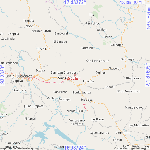
Cruztón GPS coordinates[2]
16° 45' 42.012" North, 92° 34' 45.012" West
| Map corner | latitude | longitude |
|---|---|---|
| Upper-left | 17.43372°, | -93.2823° |
| Center: | 16.76167°, | -92.57917° |
| Lower-right: | 16.08724°, | -91.87605° |
| Map W x H: | 149.7×149.7 km | = 93×93mi |
| max Lat: | 32.7° ⇑92.2% North |
| Cruztón: | 16.76167° |
| min Lat: | ⇓7.8% South 14.53588° |
| min Long | Cruztón | max Long |
| -117.105° | -92.57917° | -86.73105° |
| W 91.3%⇐ | ⇒8.7% E |
Elevation
Elevation of Cruztón is 2459 m = 8068 ft, and this is 1205.3 m = 3954 ft above average elevation for this country.
| Max E: |
3497 m = 11473 ft | 8.5% |
| Cruztón | 2459 m 8068 ft | |
| Avg. | 1253.7 m = 4113 ft | |
Min E: |
-1 m = -3 ft | 91.5% |
See also: Mexico elevation on elevation.city.
Geographical zone
Cruztón is located in North Torrid zone (between Equator and Tropic of Cancer). Distance of this Northern Tropic circle is 742.2 km =461.2 mi to North.| Distance of | km | miles | from Cruztón |
|---|---|---|---|
| North Pole | 8143.3 | 5060 | to North |
| Arctic Circle | 5537.5 | 3440.8 | to North |
| Tropic Cancer | 742.2 | 461.2 | to North |
| Equator | 1863.7 | 1158 | to South |


Nearby cities:
15 places around Cruztón: (largest is in red/bold)
• Agua de Pajarito
3.1 km =1.9 mi,  155°
155°
• Chilimjoveltic
2.9 km =1.8 mi,  359°
359°
• El Crucero
4.5 km =2.8 mi,  17°
17°
• El Pinar
2.8 km =1.7 mi,  262°
262°
• Joltzemén
6.7 km =4.2 mi,  318°
318°
• Kotolte
6.7 km =4.2 mi, 23°
• La Candelaria
6.5 km =4 mi,  108°
108°
• La Sierra
6.6 km =4.1 mi,  144°
144°
• Las Ollas
3.6 km =2.2 mi,  51°
51°
• Molino los Arcos
3.7 km =2.3 mi,  240°
240°
• Muquén
6 km =3.7 mi,  326°
326°
• Romerillo
1.3 km =0.8 mi,  72°
72°
• Saclamantón
6.6 km =4.1 mi,  296°
296°
• Sactzu
4.9 km =3 mi, 320°
• San Cristóbal de las Casas
7.4 km =4.6 mi, 243°
Sources, notices
• [Note1] Compared only with cities in Mexico existing in our database
• [Src1] Map data: © OpenStreetMap contributors (CC-BY-SA)
• [Src2] Other city data from geonames.org with taken over terms of usage.
• [Src3] Geographical zone / Annual Mean Temperature by Robert A. Rohde @ Wikipedia
