Rafael Ramírez geodata
Rafael Ramírez (Chiapas) is a populated place; located in Mexico in America/Mexico_City (GMT-6) time zone. With population of 1,075 people, there are 8116 cities with bigger population in this country. Compared to other cities in Mexico, 94.6% of cities are located further ↑North; 95.5% of cities are located further ←West and 57% of cities have lower elevation than Rafael Ramírez. Note1


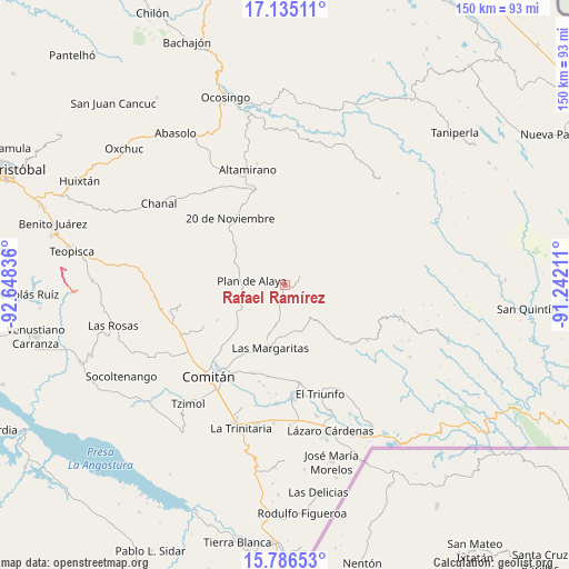
Rafael Ramírez GPS coordinates[2]
16° 27' 43.164" North, 91° 56' 42.828" West
| Map corner | latitude | longitude |
|---|---|---|
| Upper-left | 17.13511°, | -92.64836° |
| Center: | 16.46199°, | -91.94523° |
| Lower-right: | 15.78653°, | -91.24211° |
| Map W x H: | 149.9×150 km | = 93.1×93.2mi |
| max Lat: | 32.7° ⇑94.6% North |
| Rafael Ramírez: | 16.46199° |
| min Lat: | ⇓5.4% South 14.53588° |
| min Long | Rafael Ramírez | max Long |
| -117.105° | -91.94523° | -86.73105° |
| W 95.5%⇐ | ⇒4.5% E |
Elevation
Elevation of Rafael Ramírez is 1659 m = 5443 ft, and this is 405.3 m = 1330 ft above average elevation for this country.
| Max E: |
3497 m = 11473 ft | 43% |
| Rafael Ramírez | 1659 m 5443 ft | |
| Avg. | 1253.7 m = 4113 ft | |
Min E: |
-1 m = -3 ft | 57% |
See also: Mexico elevation on elevation.city.
Geographical zone
Rafael Ramírez is located in North Torrid zone (between Equator and Tropic of Cancer). Distance of this Northern Tropic circle is 775.5 km =481.9 mi to North.| Distance of | km | miles | from Rafael Ramírez |
|---|---|---|---|
| North Pole | 8176.7 | 5080.8 | to North |
| Arctic Circle | 5570.8 | 3461.5 | to North |
| Tropic Cancer | 775.5 | 481.9 | to North |
| Equator | 1830.4 | 1137.4 | to South |


Nearby cities:
15 places around Rafael Ramírez: (largest is in red/bold)
• Bajucu
12.8 km =8 mi,  276°
276°
• Belisario Domínguez
9.5 km =5.9 mi,  131°
131°
• El Encanto
13.5 km =8.4 mi,  181°
181°
• Gabino Vázquez San Sebastián
12.4 km =7.7 mi, 176°
• González de León
12.9 km =8 mi,  292°
292°
• Ignacio Zaragoza
12.4 km =7.7 mi,  166°
166°
• Jalisco
4.7 km =2.9 mi,  222°
222°
• Lomantán
12.9 km =8 mi,  259°
259°
• Mexiquito
2.3 km =1.4 mi, 286°
• Plan de Ayala
8.8 km =5.5 mi, 276°
• Saltillo
7.6 km =4.7 mi, 182°
• San Caralampio
11.7 km =7.3 mi,  348°
348°
• Santa Rita Sonora
10 km =6.2 mi,  309°
309°
• Veracruz
8.6 km =5.3 mi, 221°
• Yalcoc
14.4 km =8.9 mi,  199°
199°
Sources, notices
• [Note1] Compared only with cities in Mexico existing in our database
• [Src1] Map data: © OpenStreetMap contributors (CC-BY-SA)
• [Src2] Other city data from geonames.org with taken over terms of usage.
• [Src3] Geographical zone / Annual Mean Temperature by Robert A. Rohde @ Wikipedia
