Nuevo Vicente Guerrero geodata
Nuevo Vicente Guerrero (Chiapas) is a populated place; located in Mexico in America/Mexico_City (GMT-6) time zone. With population of 2,906 people, there are 3068 cities with bigger population in this country. Compared to other cities in Mexico, 97.1% of cities are located further ↑North; 88.7% of cities are located further ←West and 66.6% of cities have higher elevation than Nuevo Vicente Guerrero. Note1
Current local time in Nuevo Vicente Guerrero:
06:48 AM, WednesdayDifference from your time zone: hours


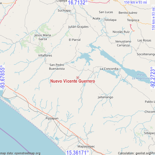
Nuevo Vicente Guerrero GPS coordinates[2]
16° 2' 18.96" North, 92° 58' 31.512" West
| Map corner | latitude | longitude |
|---|---|---|
| Upper-left | 16.7132°, | -93.67855° |
| Center: | 16.0386°, | -92.97542° |
| Lower-right: | 15.36171°, | -92.2723° |
| Map W x H: | 150.3×150.3 km | = 93.4×93.4mi |
| max Lat: | 32.7° ⇑97.1% North |
| Nuevo Vicente Guerrero: | 16.0386° |
| min Lat: | ⇓2.9% South 14.53588° |
| min Long | Nuevo Vicente G | max Long |
| -117.105° | -92.97542° | -86.73105° |
| W 88.7%⇐ | ⇒11.3% E |
Elevation
Elevation of Nuevo Vicente Guerrero is 605 m = 1985 ft, and this is 648.7 m = 2128 ft below average elevation for this country.
| Max E: |
3497 m = 11473 ft | 66.6% |
| Avg. | 1253.7 m = 4113 ft | |
| Nuevo Vicente Guerrero | 605 m = 1985 ft | |
Min E: |
-1 m = -3 ft | 33.4% |
See also: Mexico elevation on elevation.city.
Geographical zone
Nuevo Vicente Guerrero is located in North Torrid zone (between Equator and Tropic of Cancer). Distance of this Northern Tropic circle is 822.6 km =511.1 mi to North.| Distance of | km | miles | from Nuevo Vicente Guerrero |
|---|---|---|---|
| North Pole | 8223.7 | 5110 | to North |
| Arctic Circle | 5617.8 | 3490.7 | to North |
| Tropic Cancer | 822.6 | 511.1 | to North |
| Equator | 1783.3 | 1108.1 | to South |


Nearby cities:
15 places around Nuevo Vicente Guerrero: (largest is in red/bold)
• Benito Juárez
16.8 km =10.4 mi,  88°
88°
• Diamante de Echeverría
13.1 km =8.1 mi,  51°
51°
• El Ramal (Porvenir)
19.5 km =12.1 mi,  170°
170°
• El Ámbar (El Ámbar de Echeverría)
16.5 km =10.3 mi,  67°
67°
• Embarcadero de Jericó (El Siglo)
18.5 km =11.5 mi,  13°
13°
• Guadalupe Victoria
9.1 km =5.7 mi,  108°
108°
• Independencia
15.6 km =9.7 mi, 70°
• La Tigrilla
14.3 km =8.9 mi, 113°
• Loma Bonita
18.6 km =11.6 mi,  1°
1°
• Manuel Ávila Camacho
12.8 km =8 mi,  339°
339°
• Nueva Libertad
18.8 km =11.7 mi, 72°
• Plan de Agua Prieta
22.2 km =13.8 mi,  62°
62°
• Revolución Mexicana
18.3 km =11.4 mi,  323°
323°
• San Pedro Buenavista
15.9 km =9.9 mi,  288°
288°
• Santiago
11.9 km =7.4 mi, 339°
Sources, notices
• [Note1] Compared only with cities in Mexico existing in our database
• [Src1] Map data: © OpenStreetMap contributors (CC-BY-SA)
• [Src2] Other city data from geonames.org with taken over terms of usage.
• [Src3] Geographical zone / Annual Mean Temperature by Robert A. Rohde @ Wikipedia
