Hermenegildo Galeana geodata
Hermenegildo Galeana (Chiapas) is a populated place; located in Mexico in America/Mexico_City (GMT-6) time zone. With population of 1,158 people, there are 7487 cities with bigger population in this country. Compared to other cities in Mexico, 98.4% of cities are located further ↑North; 88.5% of cities are located further ←West and 80.5% of cities have higher elevation than Hermenegildo Galeana. Note1
Current local time in Hermenegildo Galeana:
08:30 AM, WednesdayDifference from your time zone: hours


Hermenegildo Galeana GPS coordinates[2]
15° 33' 8.604" North, 93° 0' 29.052" West
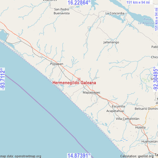
| Map corner | latitude | longitude |
|---|---|---|
| Upper-left | 16.22864°, | -93.7112° |
| Center: | 15.55239°, | -93.00807° |
| Lower-right: | 14.87391°, | -92.30495° |
| Map W x H: | 150.6×150.6 km | = 93.6×93.6mi |
| max Lat: | 32.7° ⇑98.4% North |
| Hermenegildo Galeana: | 15.55239° |
| min Lat: | ⇓1.6% South 14.53588° |
| min Long | Hermenegildo Ga | max Long |
| -117.105° | -93.00807° | -86.73105° |
| W 88.5%⇐ | ⇒11.5% E |
Elevation
Elevation of Hermenegildo Galeana is 87 m = 285 ft, and this is 1166.7 m = 3828 ft below average elevation for this country.
| Max E: |
3497 m = 11473 ft | 80.5% |
| Avg. | 1253.7 m = 4113 ft | |
| Hermenegildo Galeana | 87 m = 285 ft | |
Min E: |
-1 m = -3 ft | 19.5% |
See also: Mexico elevation on elevation.city.
Geographical zone
Hermenegildo Galeana is located in North Torrid zone (between Equator and Tropic of Cancer). Distance of this Northern Tropic circle is 876.7 km =544.8 mi to North.| Distance of | km | miles | from Hermenegildo Galeana |
|---|---|---|---|
| North Pole | 8277.8 | 5143.6 | to North |
| Arctic Circle | 5671.9 | 3524.4 | to North |
| Tropic Cancer | 876.7 | 544.8 | to North |
| Equator | 1729.3 | 1074.5 | to South |


Nearby cities:
15 places around Hermenegildo Galeana: (largest is in red/bold)
• Adolfo López Mateos
9.7 km =6 mi,  180°
180°
• Doctor Samuel León Brindis
6.4 km =4 mi,  142°
142°
• El Carmen
13.2 km =8.2 mi,  281°
281°
• Generación 2000 Nuevo Milenio
15.5 km =9.6 mi,  127°
127°
• Guadalupe Victoria
14.8 km =9.2 mi,  110°
110°
• Guanajuato
19 km =11.8 mi,  303°
303°
• Joaquín Miguel Gutiérrez (Margaritas)
9.1 km =5.7 mi,  268°
268°
• La Esperanza
20.1 km =12.5 mi,  235°
235°
• Las Brisas
12.4 km =7.7 mi,  251°
251°
• Mapastepec
17.5 km =10.9 mi, 138°
• Miguel Alemán Valdez (Jericó)
1.5 km =0.9 mi,  219°
219°
• Nueva Coapa (Estación Echegaray)
18.8 km =11.7 mi, 295°
• Nuevo Milenio Valdivia
8.4 km =5.2 mi, 130°
• Plan de Ayala
12.4 km =7.7 mi,  345°
345°
• Progreso
15.6 km =9.7 mi,  289°
289°
Sources, notices
• [Note1] Compared only with cities in Mexico existing in our database
• [Src1] Map data: © OpenStreetMap contributors (CC-BY-SA)
• [Src2] Other city data from geonames.org with taken over terms of usage.
• [Src3] Geographical zone / Annual Mean Temperature by Robert A. Rohde @ Wikipedia
