Progreso geodata
Progreso (Chiapas) is a populated place; located in Mexico in America/Mexico_City (GMT-6) time zone. With population of 867 people, there are 10083 cities with bigger population in this country. Compared to other cities in Mexico, 98.3% of cities are located further ↑North; 87.9% of cities are located further ←West and 91.2% of cities have higher elevation than Progreso. Note1


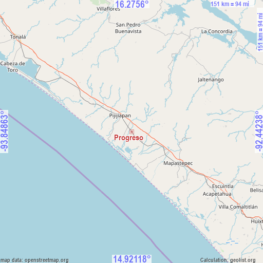
Progreso GPS coordinates[2]
15° 35' 58.236" North, 93° 8' 43.8" West
| Map corner | latitude | longitude |
|---|---|---|
| Upper-left | 16.2756°, | -93.84863° |
| Center: | 15.59951°, | -93.1455° |
| Lower-right: | 14.92118°, | -92.44238° |
| Map W x H: | 150.6×150.6 km | = 93.6×93.6mi |
| max Lat: | 32.7° ⇑98.3% North |
| Progreso: | 15.59951° |
| min Lat: | ⇓1.7% South 14.53588° |
| min Long | Progreso | max Long |
| -117.105° | -93.1455° | -86.73105° |
| W 87.9%⇐ | ⇒12.1% E |
Elevation
Elevation of Progreso is 21 m = 69 ft, and this is 1232.7 m = 4044 ft below average elevation for this country.
| Max E: |
3497 m = 11473 ft | 91.2% |
| Avg. | 1253.7 m = 4113 ft | |
| Progreso | 21 m = 69 ft | |
Min E: |
-1 m = -3 ft | 8.8% |
See also: Mexico elevation on elevation.city.
Geographical zone
Progreso is located in North Torrid zone (between Equator and Tropic of Cancer). Distance of this Northern Tropic circle is 871.4 km =541.5 mi to North.| Distance of | km | miles | from Progreso |
|---|---|---|---|
| North Pole | 8272.6 | 5140.4 | to North |
| Arctic Circle | 5666.7 | 3521.1 | to North |
| Tropic Cancer | 871.4 | 541.5 | to North |
| Equator | 1734.5 | 1077.8 | to South |


Nearby cities:
15 places around Progreso: (largest is in red/bold)
• Adolfo López Mateos
20.8 km =12.9 mi,  135°
135°
• Colonia Central
21.8 km =13.5 mi,  310°
310°
• Doctor Samuel León Brindis
21.3 km =13.2 mi,  119°
119°
• El Carmen
3.2 km =2 mi,  145°
145°
• El Palmarcito
13.5 km =8.4 mi,  212°
212°
• Guanajuato
5.4 km =3.4 mi,  348°
348°
• Hermenegildo Galeana
15.6 km =9.7 mi,  109°
109°
• Joaquín Miguel Gutiérrez (Margaritas)
7.8 km =4.8 mi,  134°
134°
• La Esperanza
16.6 km =10.3 mi,  186°
186°
• La Esperanza (El Zapotal)
16.8 km =10.4 mi, 186°
• Las Brisas
9.7 km =6 mi,  162°
162°
• Miguel Alemán Valdez (Jericó)
15.2 km =9.4 mi, 115°
• Nueva Coapa (Estación Echegaray)
3.6 km =2.2 mi,  322°
322°
• Pijijiapan
11.8 km =7.3 mi, 324°
• Plan de Ayala
13.4 km =8.3 mi,  59°
59°
Sources, notices
• [Note1] Compared only with cities in Mexico existing in our database
• [Src1] Map data: © OpenStreetMap contributors (CC-BY-SA)
• [Src2] Other city data from geonames.org with taken over terms of usage.
• [Src3] Geographical zone / Annual Mean Temperature by Robert A. Rohde @ Wikipedia
