La Esperanza geodata
La Esperanza (Chiapas) is a populated place; located in Mexico in America/Mexico_City (GMT-6) time zone. With population of 1,031 people, there are 8455 cities with bigger population in this country. Compared to other cities in Mexico, 98.6% of cities are located further ↑North; 87.8% of cities are located further ←West and 97% of cities have higher elevation than La Esperanza. Note1


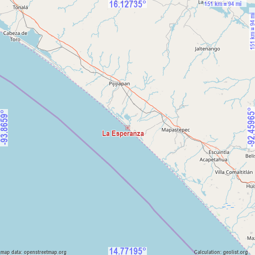
La Esperanza GPS coordinates[2]
15° 27' 2.736" North, 93° 9' 45.972" West
| Map corner | latitude | longitude |
|---|---|---|
| Upper-left | 16.12735°, | -93.8659° |
| Center: | 15.45076°, | -93.16277° |
| Lower-right: | 14.77195°, | -92.45965° |
| Map W x H: | 150.7×150.7 km | = 93.6×93.6mi |
| max Lat: | 32.7° ⇑98.6% North |
| La Esperanza: | 15.45076° |
| min Lat: | ⇓1.4% South 14.53588° |
| min Long | La Esperanza | max Long |
| -117.105° | -93.16277° | -86.73105° |
| W 87.8%⇐ | ⇒12.2% E |
Elevation
Elevation of La Esperanza is 10 m = 33 ft, and this is 1243.7 m = 4080 ft below average elevation for this country.
| Max E: |
3497 m = 11473 ft | 97% |
| Avg. | 1253.7 m = 4113 ft | |
| La Esperanza | 10 m = 33 ft | |
Min E: |
-1 m = -3 ft | 3% |
See also: Mexico elevation on elevation.city.
Geographical zone
La Esperanza is located in North Torrid zone (between Equator and Tropic of Cancer). Distance of this Northern Tropic circle is 888 km =551.8 mi to North.| Distance of | km | miles | from La Esperanza |
|---|---|---|---|
| North Pole | 8289.1 | 5150.6 | to North |
| Arctic Circle | 5683.2 | 3531.4 | to North |
| Tropic Cancer | 888 | 551.8 | to North |
| Equator | 1718 | 1067.5 | to South |


Nearby cities:
15 places around La Esperanza: (largest is in red/bold)
• Adolfo López Mateos
16.5 km =10.3 mi,  84°
84°
• Doctor Samuel León Brindis
21.4 km =13.3 mi,  73°
73°
• El Carmen
14.3 km =8.9 mi,  14°
14°
• El Palmarcito
7.5 km =4.7 mi,  313°
313°
• Guanajuato
21.8 km =13.5 mi,  1°
1°
• Hermenegildo Galeana
20.1 km =12.5 mi,  55°
55°
• Joaquín Miguel Gutiérrez (Margaritas)
13.4 km =8.3 mi,  34°
34°
• La Esperanza (El Zapotal)
0.2 km =0.1 mi,  220°
220°
• Las Brisas
8.8 km =5.5 mi, 33°
• Miguel Alemán Valdez (Jericó)
18.6 km =11.6 mi, 57°
• Nueva Coapa (Estación Echegaray)
19.4 km =12.1 mi,  358°
358°
• Nuevo Milenio Valdivia
23.7 km =14.7 mi, 75°
• Pijijiapan
26.6 km =16.5 mi,  349°
349°
• Plan de Ayala
26.9 km =16.7 mi, 30°
• Progreso
16.6 km =10.3 mi, 6°
Sources, notices
• [Note1] Compared only with cities in Mexico existing in our database
• [Src1] Map data: © OpenStreetMap contributors (CC-BY-SA)
• [Src2] Other city data from geonames.org with taken over terms of usage.
• [Src3] Geographical zone / Annual Mean Temperature by Robert A. Rohde @ Wikipedia
