La Esperanza (El Zapotal) geodata
La Esperanza (El Zapotal) (Chiapas) is a populated place; located in Mexico in America/Mexico_City (GMT-6) time zone. With population of 1,031 people, there are 8455 cities with bigger population in this country. Compared to other cities in Mexico, 98.7% of cities are located further ↑North; 87.8% of cities are located further ←West and 95.7% of cities have higher elevation than La Esperanza (El Zapotal). Note1
Current local time in La Esperanza (El Zapotal):
08:36 AM, WednesdayDifference from your time zone: hours


La Esperanza (El Zapotal) GPS coordinates[2]
15° 26' 57.012" North, 93° 9' 51.012" West
| Map corner | latitude | longitude |
|---|---|---|
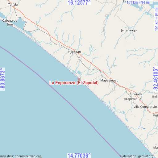
| Upper-left | 16.12577°, | -93.8673° |
| Center: | 15.44917°, | -93.16417° |
| Lower-right: | 14.77036°, | -92.46105° |
| Map W x H: | 150.7×150.7 km | = 93.6×93.6mi |
| max Lat: | 32.7° ⇑98.7% North |
| La Esperanza (El Zapotal): | 15.44917° |
| min Lat: | ⇓1.3% South 14.53588° |
| min Long | La Esperanza (E | max Long |
| -117.105° | -93.16417° | -86.73105° |
| W 87.8%⇐ | ⇒12.2% E |
Elevation
Elevation of La Esperanza (El Zapotal) is 12 m = 39 ft, and this is 1241.7 m = 4074 ft below average elevation for this country.
| Max E: |
3497 m = 11473 ft | 95.7% |
| Avg. | 1253.7 m = 4113 ft | |
| La Esperanza (El Zapotal) | 12 m = 39 ft | |
Min E: |
-1 m = -3 ft | 4.3% |
See also: Mexico elevation on elevation.city.
Geographical zone
La Esperanza (El Zapotal) is located in North Torrid zone (between Equator and Tropic of Cancer). Distance of this Northern Tropic circle is 888.1 km =551.8 mi to North.| Distance of | km | miles | from La Esperanza (El Zapotal) |
|---|---|---|---|
| North Pole | 8289.3 | 5150.7 | to North |
| Arctic Circle | 5683.4 | 3531.5 | to North |
| Tropic Cancer | 888.1 | 551.8 | to North |
| Equator | 1717.8 | 1067.4 | to South |


Nearby cities:
15 places around La Esperanza (El Zapotal): (largest is in red/bold)
• Adolfo López Mateos
16.7 km =10.4 mi,  83°
83°
• Doctor Samuel León Brindis
21.6 km =13.4 mi,  72°
72°
• El Carmen
14.6 km =9.1 mi,  15°
15°
• El Palmarcito
7.5 km =4.7 mi,  315°
315°
• Guanajuato
22 km =13.7 mi,  2°
2°
• Hermenegildo Galeana
20.3 km =12.6 mi,  55°
55°
• Joaquín Miguel Gutiérrez (Margaritas)
13.6 km =8.5 mi,  34°
34°
• La Esperanza
0.2 km =0.1 mi,  40°
40°
• Las Brisas
9 km =5.6 mi, 33°
• Miguel Alemán Valdez (Jericó)
18.8 km =11.7 mi, 56°
• Nueva Coapa (Estación Echegaray)
19.6 km =12.2 mi,  359°
359°
• Nuevo Milenio Valdivia
23.9 km =14.9 mi, 75°
• Pijijiapan
26.8 km =16.7 mi,  349°
349°
• Plan de Ayala
27.1 km =16.8 mi, 30°
• Progreso
16.8 km =10.4 mi,  6°
6°
Sources, notices
• [Note1] Compared only with cities in Mexico existing in our database
• [Src1] Map data: © OpenStreetMap contributors (CC-BY-SA)
• [Src2] Other city data from geonames.org with taken over terms of usage.
• [Src3] Geographical zone / Annual Mean Temperature by Robert A. Rohde @ Wikipedia
