La Lagunilla geodata
La Lagunilla (State of Mexico) is a populated place; located in Mexico in America/Mexico_City (GMT-6) time zone. With population of 680 people, there are 12778 cities with bigger population in this country. Compared to other cities in Mexico, 66.4% of cities are located further ↑North; 58.9% of cities are located further →East and 73.8% of cities have lower elevation than La Lagunilla. Note1


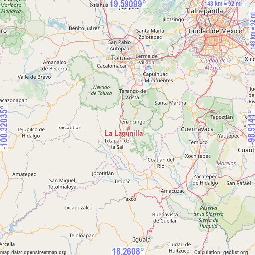
La Lagunilla GPS coordinates[2]
18° 55' 37.992" North, 99° 37' 1.992" West
| Map corner | latitude | longitude |
|---|---|---|
| Upper-left | 19.59099°, | -100.32035° |
| Center: | 18.92722°, | -99.61722° |
| Lower-right: | 18.2608°, | -98.9141° |
| Map W x H: | 147.9×147.9 km | = 91.9×91.9mi |
| max Lat: | 32.7° ⇑66.4% North |
| La Lagunilla: | 18.92722° |
| min Lat: | ⇓33.6% South 14.53588° |
| min Long | La Lagunilla | max Long |
| -117.105° | -99.61722° | -86.73105° |
| W 41.1%⇐ | ⇒58.9% E |
Elevation
Elevation of La Lagunilla is 2006 m = 6581 ft, and this is 752.3 m = 2468 ft above average elevation for this country.
| Max E: |
3497 m = 11473 ft | 26.2% |
| La Lagunilla | 2006 m 6581 ft | |
| Avg. | 1253.7 m = 4113 ft | |
Min E: |
-1 m = -3 ft | 73.8% |
See also: Mexico elevation on elevation.city.
Geographical zone
La Lagunilla is located in North Torrid zone (between Equator and Tropic of Cancer). Distance of this Northern Tropic circle is 501.4 km =311.6 mi to North.| Distance of | km | miles | from La Lagunilla |
|---|---|---|---|
| North Pole | 7902.6 | 4910.4 | to North |
| Arctic Circle | 5296.7 | 3291.2 | to North |
| Tropic Cancer | 501.4 | 311.6 | to North |
| Equator | 2104.5 | 1307.7 | to South |


Nearby cities:
15 places around La Lagunilla: (largest is in red/bold)
• Acatzingo (Acatzingo de la Piedra)
3 km =1.9 mi,  97°
97°
• Coxcacoaco
3.2 km =2 mi,  339°
339°
• Ejido de San Mateo Coapexco
3.6 km =2.2 mi,  312°
312°
• El Salitre
4 km =2.5 mi,  45°
45°
• Ixpuichiapan
3.2 km =2 mi,  78°
78°
• Jesús Carranza (Rancho de Jesús)
2.4 km =1.5 mi,  325°
325°
• Potrero Nuevo
3.4 km =2.1 mi,  201°
201°
• Pueblo Nuevo
4.2 km =2.6 mi,  56°
56°
• Quetzalapa
2.6 km =1.6 mi, 55°
• San Antonio Guadalupe
2.9 km =1.8 mi,  152°
152°
• San Felipe
4 km =2.5 mi,  279°
279°
• San Francisco
4 km =2.5 mi, 307°
• Tepalcatepec
2.1 km =1.3 mi, 63°
• Tepetzingo
1.3 km =0.8 mi,  22°
22°
• Terrenate
2.5 km =1.6 mi,  89°
89°
Sources, notices
• [Note1] Compared only with cities in Mexico existing in our database
• [Src1] Map data: © OpenStreetMap contributors (CC-BY-SA)
• [Src2] Other city data from geonames.org with taken over terms of usage.
• [Src3] Geographical zone / Annual Mean Temperature by Robert A. Rohde @ Wikipedia
