San Lorenzo Nenamicoyan geodata
San Lorenzo Nenamicoyan (Morelos) is a populated place; located in Mexico in America/Mexico_City (GMT-6) time zone. With population of 2,008 people, there are 4332 cities with bigger population in this country. Compared to other cities in Mexico, 59.9% of cities are located further ↓South; 59.2% of cities are located further →East and 98.3% of cities have lower elevation than San Lorenzo Nenamicoyan. Note1
Current local time in San Lorenzo Nenamicoyan:
11:19 AM, MondayDifference from your time zone: hours


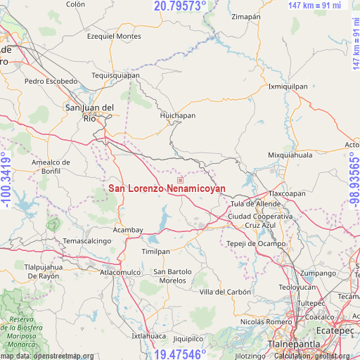
San Lorenzo Nenamicoyan GPS coordinates[2]
20° 8' 13.164" North, 99° 38' 19.572" West
| Map corner | latitude | longitude |
|---|---|---|
| Upper-left | 20.79573°, | -100.3419° |
| Center: | 20.13699°, | -99.63877° |
| Lower-right: | 19.47546°, | -98.93565° |
| Map W x H: | 146.8×146.8 km | = 91.2×91.2mi |
| max Lat: | 32.7° ⇑40.1% North |
| San Lorenzo Nenamicoyan: | 20.13699° |
| min Lat: | ⇓59.9% South 14.53588° |
| min Long | San Lorenzo Nen | max Long |
| -117.105° | -99.63877° | -86.73105° |
| W 40.8%⇐ | ⇒59.2% E |
Elevation
Elevation of San Lorenzo Nenamicoyan is 2773 m = 9098 ft, and this is 1519.3 m = 4985 ft above average elevation for this country.
| Max E: |
3497 m = 11473 ft | 1.7% |
| San Lorenzo Nenamicoyan | 2773 m 9098 ft | |
| Avg. | 1253.7 m = 4113 ft | |
Min E: |
-1 m = -3 ft | 98.3% |
See also: Mexico elevation on elevation.city.
Geographical zone
San Lorenzo Nenamicoyan is located in North Torrid zone (between Equator and Tropic of Cancer). Distance of this Northern Tropic circle is 366.9 km =228 mi to North.| Distance of | km | miles | from San Lorenzo Nenamicoyan |
|---|---|---|---|
| North Pole | 7768 | 4826.8 | to North |
| Arctic Circle | 5162.2 | 3207.6 | to North |
| Tropic Cancer | 366.9 | 228 | to North |
| Equator | 2239 | 1391.2 | to South |


Nearby cities:
15 places around San Lorenzo Nenamicoyan: (largest is in red/bold)
• El Bonxhi
12.6 km =7.8 mi,  237°
237°
• El Jagüey
12.5 km =7.8 mi,  11°
11°
• El Rosal
6.3 km =3.9 mi,  230°
230°
• Las Lajas
12.2 km =7.6 mi,  253°
253°
• Maravillas
9.2 km =5.7 mi,  35°
35°
• San Antonio Arroyo Zarco
11.4 km =7.1 mi, 241°
• San José Deguedó
9.6 km =6 mi,  126°
126°
• San Juan Daxthi
12.5 km =7.8 mi,  110°
110°
• San Martín Ejido
9.3 km =5.8 mi,  218°
218°
• San Martín Tuchicuitlapilco
4.9 km =3 mi,  189°
189°
• San Miguel de La Victoria
10.3 km =6.4 mi,  151°
151°
• San Sebastián de Juárez
11.5 km =7.1 mi,  71°
71°
• San Vicente (Calpulalpan Tercera Manzana)
11.1 km =6.9 mi,  181°
181°
• Santiago Oxthoc
10.1 km =6.3 mi,  103°
103°
• Tecolapan
6.6 km =4.1 mi,  155°
155°
Sources, notices
• [Note1] Compared only with cities in Mexico existing in our database
• [Src1] Map data: © OpenStreetMap contributors (CC-BY-SA)
• [Src2] Other city data from geonames.org with taken over terms of usage.
• [Src3] Geographical zone / Annual Mean Temperature by Robert A. Rohde @ Wikipedia
