San Juan Daxthi geodata
San Juan Daxthi (State of Mexico) is a populated place; located in Mexico in America/Mexico_City (GMT-6) time zone. With population of 1,089 people, there are 7989 cities with bigger population in this country. Compared to other cities in Mexico, 59.1% of cities are located further ↓South; 57.2% of cities are located further →East and 88.9% of cities have lower elevation than San Juan Daxthi. Note1


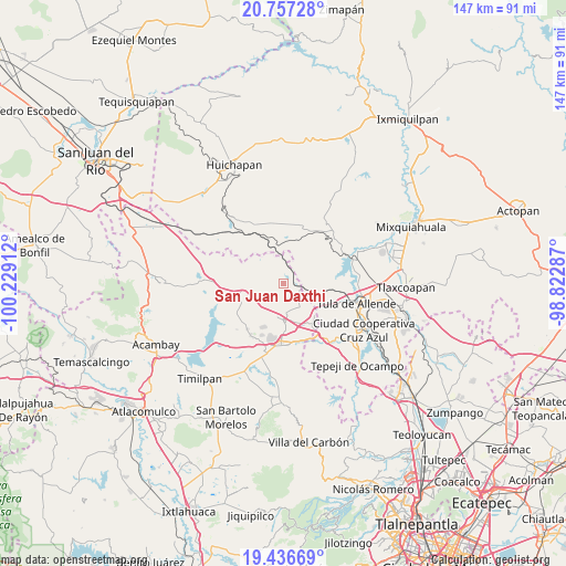
San Juan Daxthi GPS coordinates[2]
20° 5' 54.168" North, 99° 31' 33.564" West
| Map corner | latitude | longitude |
|---|---|---|
| Upper-left | 20.75728°, | -100.22912° |
| Center: | 20.09838°, | -99.52599° |
| Lower-right: | 19.43669°, | -98.82287° |
| Map W x H: | 146.8×146.8 km | = 91.2×91.2mi |
| max Lat: | 32.7° ⇑40.9% North |
| San Juan Daxthi: | 20.09838° |
| min Lat: | ⇓59.1% South 14.53588° |
| min Long | San Juan Daxthi | max Long |
| -117.105° | -99.52599° | -86.73105° |
| W 42.8%⇐ | ⇒57.2% E |
Elevation
Elevation of San Juan Daxthi is 2369 m = 7772 ft, and this is 1115.3 m = 3659 ft above average elevation for this country.
| Max E: |
3497 m = 11473 ft | 11.1% |
| San Juan Daxthi | 2369 m 7772 ft | |
| Avg. | 1253.7 m = 4113 ft | |
Min E: |
-1 m = -3 ft | 88.9% |
See also: Mexico elevation on elevation.city.
Geographical zone
San Juan Daxthi is located in North Torrid zone (between Equator and Tropic of Cancer). Distance of this Northern Tropic circle is 371.2 km =230.7 mi to North.| Distance of | km | miles | from San Juan Daxthi |
|---|---|---|---|
| North Pole | 7772.3 | 4829.5 | to North |
| Arctic Circle | 5166.4 | 3210.3 | to North |
| Tropic Cancer | 371.2 | 230.7 | to North |
| Equator | 2234.7 | 1388.6 | to South |


Nearby cities:
15 places around San Juan Daxthi: (largest is in red/bold)
• La Comunidad
10.1 km =6.3 mi,  211°
211°
• Michimaloya
13.3 km =8.3 mi,  93°
93°
• San Agustín Buenavista
7.2 km =4.5 mi,  148°
148°
• San José Deguedó
4.2 km =2.6 mi,  250°
250°
• San Lorenzo Nenamicoyan
12.5 km =7.8 mi,  290°
290°
• San Martín Tuchicuitlapilco
12.6 km =7.8 mi,  267°
267°
• San Miguel de La Victoria
8.3 km =5.2 mi,  235°
235°
• San Pablo Huantepec
13.4 km =8.3 mi,  164°
164°
• San Sebastián de Juárez
8.1 km =5 mi,  353°
353°
• Santa Maria Macua
6.7 km =4.2 mi,  51°
51°
• Santiago Oxthoc
2.7 km =1.7 mi,  315°
315°
• Soyaniquilpan
9.3 km =5.8 mi,  182°
182°
• Tecolapan
9.2 km =5.7 mi,  259°
259°
• Xhitey
13 km =8.1 mi, 180°
• Xiteje de la Reforma
6.5 km =4 mi,  41°
41°
Sources, notices
• [Note1] Compared only with cities in Mexico existing in our database
• [Src1] Map data: © OpenStreetMap contributors (CC-BY-SA)
• [Src2] Other city data from geonames.org with taken over terms of usage.
• [Src3] Geographical zone / Annual Mean Temperature by Robert A. Rohde @ Wikipedia
