Icxotitla geodata
Icxotitla (Puebla) is a populated place; located in Mexico in America/Mexico_City (GMT-6) time zone. With population of 1,369 people, there are 6339 cities with bigger population in this country. Compared to other cities in Mexico, 62.3% of cities are located further ↓South; 62.5% of cities are located further ←West and 50.5% of cities have lower elevation than Icxotitla. Note1


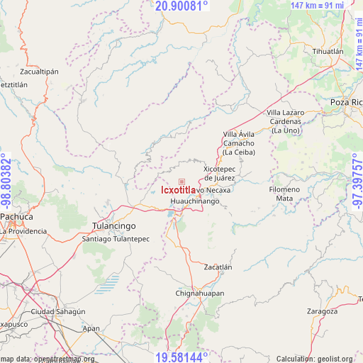
Icxotitla GPS coordinates[2]
20° 14' 33.108" North, 98° 6' 2.484" West
| Map corner | latitude | longitude |
|---|---|---|
| Upper-left | 20.90081°, | -98.80382° |
| Center: | 20.24253°, | -98.10069° |
| Lower-right: | 19.58144°, | -97.39757° |
| Map W x H: | 146.7×146.7 km | = 91.2×91.2mi |
| max Lat: | 32.7° ⇑37.7% North |
| Icxotitla: | 20.24253° |
| min Lat: | ⇓62.3% South 14.53588° |
| min Long | Icxotitla | max Long |
| -117.105° | -98.10069° | -86.73105° |
| W 62.5%⇐ | ⇒37.5% E |
Elevation
Elevation of Icxotitla is 1457 m = 4780 ft, and this is 203.3 m = 667 ft above average elevation for this country.
| Max E: |
3497 m = 11473 ft | 49.5% |
| Icxotitla | 1457 m 4780 ft | |
| Avg. | 1253.7 m = 4113 ft | |
Min E: |
-1 m = -3 ft | 50.5% |
See also: Mexico elevation on elevation.city.
Geographical zone
Icxotitla is located in North Torrid zone (between Equator and Tropic of Cancer). Distance of this Northern Tropic circle is 355.2 km =220.7 mi to North.| Distance of | km | miles | from Icxotitla |
|---|---|---|---|
| North Pole | 7756.3 | 4819.5 | to North |
| Arctic Circle | 5150.4 | 3200.3 | to North |
| Tropic Cancer | 355.2 | 220.7 | to North |
| Equator | 2250.8 | 1398.6 | to South |


Nearby cities:
15 places around Icxotitla: (largest is in red/bold)
• Atla
4.4 km =2.7 mi,  325°
325°
• Atlantongo
3.1 km =1.9 mi,  323°
323°
• Chachahuantla
5.6 km =3.5 mi,  216°
216°
• Copila
3.9 km =2.4 mi,  28°
28°
• Cuahuihuitzotitla
5 km =3.1 mi,  200°
200°
• Cueyatla
5.8 km =3.6 mi,  18°
18°
• Huilacapixtla
3.9 km =2.4 mi,  149°
149°
• Naupan
1.5 km =0.9 mi,  214°
214°
• Paciotla
7.4 km =4.6 mi, 323°
• Pahuatlán de Valle
6.5 km =4 mi,  307°
307°
• San Francisco Atotonilco
7.5 km =4.7 mi,  225°
225°
• Tlalcruz de Libres
7 km =4.3 mi,  350°
350°
• Tlaxpanaloya
2.8 km =1.7 mi, 227°
• Xolotla
3.8 km =2.4 mi,  296°
296°
• Zoyatla de Guerrero
7.2 km =4.5 mi,  335°
335°
Sources, notices
• [Note1] Compared only with cities in Mexico existing in our database
• [Src1] Map data: © OpenStreetMap contributors (CC-BY-SA)
• [Src2] Other city data from geonames.org with taken over terms of usage.
• [Src3] Geographical zone / Annual Mean Temperature by Robert A. Rohde @ Wikipedia
