Mazapiltepec geodata
Mazapiltepec (Puebla) is a seat of a second-order administrative division; located in Mexico in America/Mexico_City (GMT-6) time zone. With population of 1,425 people, there are 6062 cities with bigger population in this country. Compared to other cities in Mexico, 62.8% of cities are located further ↑North; 67.2% of cities are located further ←West and 90.2% of cities have lower elevation than Mazapiltepec. Note1


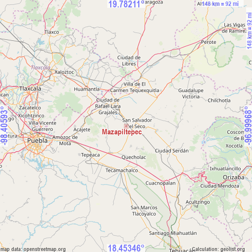
Mazapiltepec GPS coordinates[2]
19° 7' 8.832" North, 97° 42' 10.08" West
| Map corner | latitude | longitude |
|---|---|---|
| Upper-left | 19.78211°, | -98.40593° |
| Center: | 19.11912°, | -97.7028° |
| Lower-right: | 18.45346°, | -96.99968° |
| Map W x H: | 147.7×147.7 km | = 91.8×91.8mi |
| max Lat: | 32.7° ⇑62.8% North |
| Mazapiltepec: | 19.11912° |
| min Lat: | ⇓37.2% South 14.53588° |
| min Long | Mazapiltepec | max Long |
| -117.105° | -97.7028° | -86.73105° |
| W 67.2%⇐ | ⇒32.8% E |
Elevation
Elevation of Mazapiltepec is 2413 m = 7917 ft, and this is 1159.3 m = 3803 ft above average elevation for this country.
| Max E: |
3497 m = 11473 ft | 9.8% |
| Mazapiltepec | 2413 m 7917 ft | |
| Avg. | 1253.7 m = 4113 ft | |
Min E: |
-1 m = -3 ft | 90.2% |
See also: Mexico elevation on elevation.city.
Geographical zone
Mazapiltepec is located in North Torrid zone (between Equator and Tropic of Cancer). Distance of this Northern Tropic circle is 480.1 km =298.3 mi to North.| Distance of | km | miles | from Mazapiltepec |
|---|---|---|---|
| North Pole | 7881.2 | 4897.1 | to North |
| Arctic Circle | 5275.3 | 3277.9 | to North |
| Tropic Cancer | 480.1 | 298.3 | to North |
| Equator | 2125.8 | 1320.9 | to South |


Nearby cities:
15 places around Mazapiltepec: (largest is in red/bold)
• Candelaria Portezuelo
8.6 km =5.3 mi,  178°
178°
• Colonia Benito Juárez
9.5 km =5.9 mi,  294°
294°
• Eréndira
7.6 km =4.7 mi,  299°
299°
• Guadalupe Victoria
10.3 km =6.4 mi,  99°
99°
• Hernández
10.6 km =6.6 mi,  254°
254°
• La Ermita
8.9 km =5.5 mi,  269°
269°
• Libertad Álvaro Obregón
7 km =4.3 mi,  284°
284°
• Manuel Ávila Camacho (La Cima)
11.4 km =7.1 mi, 274°
• San José Barroso
11.5 km =7.1 mi,  47°
47°
• San Martín Rinconada
3.8 km =2.4 mi,  85°
85°
• San Mateo Soltepec
6.5 km =4 mi, 249°
• San Salvador El Seco
6.6 km =4.1 mi,  76°
76°
• San Sebastián Villanueva
6.7 km =4.2 mi,  195°
195°
• Soltepec
0.6 km =0.4 mi, 289°
• Vista Hermosa
2.9 km =1.8 mi, 268°
Sources, notices
• [Note1] Compared only with cities in Mexico existing in our database
• [Src1] Map data: © OpenStreetMap contributors (CC-BY-SA)
• [Src2] Other city data from geonames.org with taken over terms of usage.
• [Src3] Geographical zone / Annual Mean Temperature by Robert A. Rohde @ Wikipedia
