Guadalupe Victoria geodata
Guadalupe Victoria (Puebla) is a populated place; located in Mexico in America/Mexico_City (GMT-6) time zone. With population of 857 people, there are 10207 cities with bigger population in this country. Compared to other cities in Mexico, 72.2% of cities are located further ↑North; 65.5% of cities are located further ←West and 68.9% of cities have lower elevation than Guadalupe Victoria. Note1


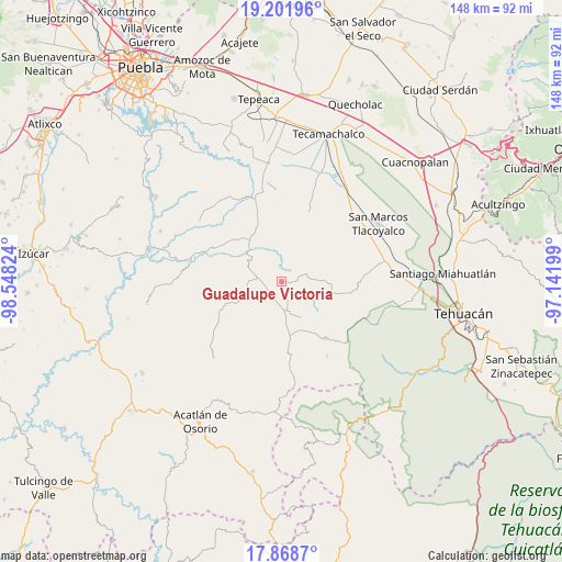
Guadalupe Victoria GPS coordinates[2]
18° 32' 11.868" North, 97° 50' 42.396" West
| Map corner | latitude | longitude |
|---|---|---|
| Upper-left | 19.20196°, | -98.54824° |
| Center: | 18.53663°, | -97.84511° |
| Lower-right: | 17.8687°, | -97.14199° |
| Map W x H: | 148.2×148.2 km | = 92.1×92.1mi |
| max Lat: | 32.7° ⇑72.2% North |
| Guadalupe Victoria: | 18.53663° |
| min Lat: | ⇓27.8% South 14.53588° |
| min Long | Guadalupe Victo | max Long |
| -117.105° | -97.84511° | -86.73105° |
| W 65.5%⇐ | ⇒34.5% E |
Elevation
Elevation of Guadalupe Victoria is 1905 m = 6250 ft, and this is 651.3 m = 2137 ft above average elevation for this country.
| Max E: |
3497 m = 11473 ft | 31.1% |
| Guadalupe Victoria | 1905 m 6250 ft | |
| Avg. | 1253.7 m = 4113 ft | |
Min E: |
-1 m = -3 ft | 68.9% |
See also: Mexico elevation on elevation.city.
Geographical zone
Guadalupe Victoria is located in North Torrid zone (between Equator and Tropic of Cancer). Distance of this Northern Tropic circle is 544.8 km =338.5 mi to North.| Distance of | km | miles | from Guadalupe Victoria |
|---|---|---|---|
| North Pole | 7946 | 4937.4 | to North |
| Arctic Circle | 5340.1 | 3318.2 | to North |
| Tropic Cancer | 544.8 | 338.5 | to North |
| Equator | 2061.1 | 1280.7 | to South |


Nearby cities:
15 places around Guadalupe Victoria: (largest is in red/bold)
• Agua Santa Ana
11.9 km =7.4 mi,  258°
258°
• Almolonga
14.2 km =8.8 mi,  241°
241°
• Colonia Morelos (Pie de Vaca)
9.9 km =6.2 mi,  311°
311°
• El Progreso
3 km =1.9 mi,  333°
333°
• Huajoyuca
10.1 km =6.3 mi,  254°
254°
• Huejonapan
11 km =6.8 mi,  227°
227°
• Juan N. Méndez
7.7 km =4.8 mi,  84°
84°
• Magdalena Alquizapán
10.9 km =6.8 mi,  124°
124°
• Mariscala
8 km =5 mi, 254°
• Moralillo
10.5 km =6.5 mi,  276°
276°
• San José de Gracia
11.9 km =7.4 mi,  358°
358°
• San Juan Ixcaquixtla
8.6 km =5.3 mi,  170°
170°
• San Mateo Zoyamazalco
13.7 km =8.5 mi,  159°
159°
• Tepexi de Rodríguez
9.9 km =6.2 mi,  300°
300°
• Tula
6.8 km =4.2 mi,  271°
271°
Sources, notices
• [Note1] Compared only with cities in Mexico existing in our database
• [Src1] Map data: © OpenStreetMap contributors (CC-BY-SA)
• [Src2] Other city data from geonames.org with taken over terms of usage.
• [Src3] Geographical zone / Annual Mean Temperature by Robert A. Rohde @ Wikipedia
